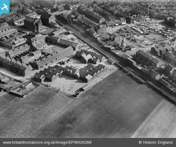
EPW026388 ENGLAND (1929). Earlestown Infant School and the Market Place, Earlestown, 1929
© Hawlfraint cyfranwyr OpenStreetMap a thrwyddedwyd gan yr OpenStreetMap Foundation. 2026. Trwyddedir y gartograffeg fel CC BY-SA.
Manylion
| Pennawd | [EPW026388] Earlestown Infant School and the Market Place, Earlestown, 1929 |
| Cyfeirnod | EPW026388 |
| Dyddiad | April-1929 |
| Dolen | |
| Enw lle | EARLESTOWN |
| Plwyf | |
| Ardal | |
| Gwlad | ENGLAND |
| Dwyreiniad / Gogleddiad | 357503, 395463 |
| Hydred / Lledred | -2.6400385716571, 53.453952362216 |
| Cyfeirnod Grid Cenedlaethol | SJ575955 |
Pinnau

NeilRobertson |
Thursday 30th of September 2021 08:28:12 PM | |

NeilRobertson |
Thursday 30th of September 2021 08:27:27 PM | |

NeilRobertson |
Thursday 30th of September 2021 08:26:43 PM | |

St Helens Pubs |
Monday 26th of September 2016 01:53:08 PM | |

St Helens Pubs |
Monday 26th of September 2016 01:43:58 PM | |

Dave |
Thursday 31st of October 2013 12:40:59 PM |


![[EPW026388] Earlestown Infant School and the Market Place, Earlestown, 1929](http://britainfromabove.org.uk/sites/all/libraries/aerofilms-images/public/100x100/EPW/026/EPW026388.jpg)
![[EPW026387] The Market Place and Town Hall, Earlestown, 1929](http://britainfromabove.org.uk/sites/all/libraries/aerofilms-images/public/100x100/EPW/026/EPW026387.jpg)
![[EPW026385] St John the Baptist's Church, the Market Place and Town Hall, Earlestown, 1929](http://britainfromabove.org.uk/sites/all/libraries/aerofilms-images/public/100x100/EPW/026/EPW026385.jpg)
![[EPW026384] Housing off King Street and Queen Street, Earlestown, 1929](http://britainfromabove.org.uk/sites/all/libraries/aerofilms-images/public/100x100/EPW/026/EPW026384.jpg)
