
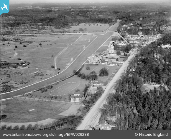
EPW026288 ENGLAND (1929). Ascot Racecourse home straight, grandstands and paddocks, Ascot, from the west, 1929
© Hawlfraint cyfranwyr OpenStreetMap a thrwyddedwyd gan yr OpenStreetMap Foundation. 2026. Trwyddedir y gartograffeg fel CC BY-SA.
Delweddau cyfagos (14)
EPW026288

EPW008714

EAW022116

EPW013406

EPW008716

EPW013402

EPW026283

EPW008710
, Ascot, 1923")
EPW008715

EPW036159

EPW006706

EPW036162

EPW036161

EPW006708

Manylion
| Pennawd | [EPW026288] Ascot Racecourse home straight, grandstands and paddocks, Ascot, from the west, 1929 |
| Cyfeirnod | EPW026288 |
| Dyddiad | 25-April-1929 |
| Dolen | |
| Enw lle | ASCOT |
| Plwyf | SUNNINGHILL AND ASCOT |
| Ardal | |
| Gwlad | ENGLAND |
| Dwyreiniad / Gogleddiad | 491630, 168871 |
| Hydred / Lledred | -0.68233907757405, 51.410954279211 |
| Cyfeirnod Grid Cenedlaethol | SU916689 |
Pinnau
Byddwch y cyntaf i ychwanegu sylw at y ddelwedd hon!