
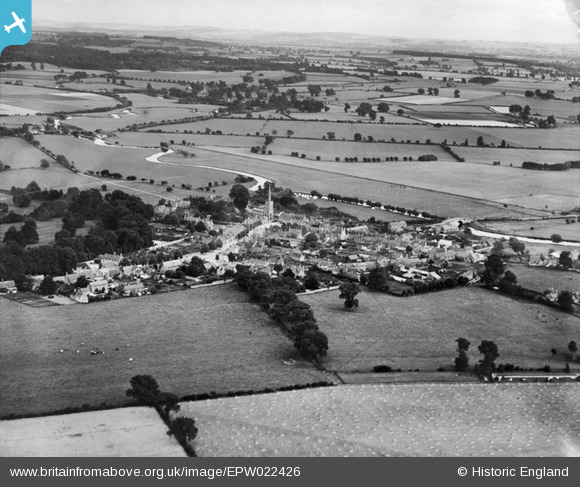
EPW022426 ENGLAND (1928). The town, Lechlade on Thames, from the north-west, 1928
© Hawlfraint cyfranwyr OpenStreetMap a thrwyddedwyd gan yr OpenStreetMap Foundation. 2026. Trwyddedir y gartograffeg fel CC BY-SA.
Delweddau cyfagos (2)
EPW022426

EPW022427

Manylion
| Pennawd | [EPW022426] The town, Lechlade on Thames, from the north-west, 1928 |
| Cyfeirnod | EPW022426 |
| Dyddiad | August-1928 |
| Dolen | |
| Enw lle | LECHLADE ON THAMES |
| Plwyf | LECHLADE |
| Ardal | |
| Gwlad | ENGLAND |
| Dwyreiniad / Gogleddiad | 421226, 199828 |
| Hydred / Lledred | -1.692854733474, 51.696337678278 |
| Cyfeirnod Grid Cenedlaethol | SU212998 |
Pinnau

Eagle eye |
Sunday 22nd of February 2015 09:09:17 PM | |
|
Eagle eye |
Sunday 22nd of February 2015 09:07:25 PM | |
|
Eagle eye |
Monday 2nd of February 2015 10:40:48 PM | |
Lynda Tubbs |
Tuesday 14th of January 2014 03:13:55 PM | |
Lynda Tubbs |
Wednesday 16th of October 2013 03:17:23 PM | |
Lynda Tubbs |
Wednesday 16th of October 2013 03:10:37 PM | |
From the earliest Ordnance Survey maps this has been known as Bridge Walk not Monk's walk. |
Eagle eye |
Monday 2nd of February 2015 10:48:43 PM |
Lynda Tubbs |
Wednesday 17th of July 2013 07:11:06 PM | |
Lynda Tubbs |
Tuesday 23rd of April 2013 02:17:00 PM | |
Lynda Tubbs |
Tuesday 23rd of April 2013 02:14:34 PM | |
Lynda Tubbs |
Wednesday 20th of February 2013 12:02:21 PM |
Cyfraniadau Grŵp
See the River Thames meandering along in this image. |
Lynda Tubbs |
Wednesday 25th of June 2014 03:05:57 PM |
|
|
Hefin Meara |
Tuesday 22nd of January 2013 11:22:54 AM |