
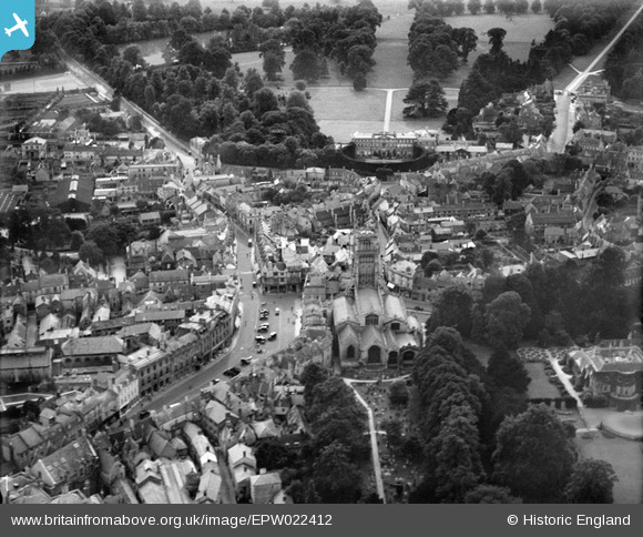
EPW022412 ENGLAND (1928). St John the Baptist's Church and Cirencester Park, Cirencester, 1928
© Hawlfraint cyfranwyr OpenStreetMap a thrwyddedwyd gan yr OpenStreetMap Foundation. 2026. Trwyddedir y gartograffeg fel CC BY-SA.
Delweddau cyfagos (19)
EPW022412

EPW022416

EPW022410

EPW006310

EAW031681

EAW031677

EPW022407

EAW006877

EPW022413

EAW031680

EPW061776

EPW061775

EPW022417

EPW061780

EAW015789

EAW015788

EPW022415

EAW006878

EPW022408

Manylion
| Pennawd | [EPW022412] St John the Baptist's Church and Cirencester Park, Cirencester, 1928 |
| Cyfeirnod | EPW022412 |
| Dyddiad | August-1928 |
| Dolen | |
| Enw lle | CIRENCESTER |
| Plwyf | CIRENCESTER |
| Ardal | |
| Gwlad | ENGLAND |
| Dwyreiniad / Gogleddiad | 402252, 202056 |
| Hydred / Lledred | -1.9673983772453, 51.71676922293 |
| Cyfeirnod Grid Cenedlaethol | SP023021 |
Pinnau

Alan McFaden |
Wednesday 21st of May 2014 10:05:14 PM | |
|
Alan McFaden |
Wednesday 21st of May 2014 09:39:40 PM | |
|
Alan McFaden |
Wednesday 21st of May 2014 09:39:03 PM | |

SydM |
Saturday 8th of March 2014 05:53:50 PM | |

Class31 |
Monday 10th of June 2013 09:31:53 PM | |
|
Class31 |
Thursday 24th of January 2013 08:30:37 PM | |
|
Class31 |
Thursday 24th of January 2013 08:27:24 PM | |
|
Class31 |
Thursday 24th of January 2013 08:25:34 PM | |
|
Class31 |
Thursday 24th of January 2013 08:24:34 PM | |
|
Class31 |
Thursday 24th of January 2013 08:23:52 PM | |
|
Class31 |
Thursday 24th of January 2013 08:23:17 PM | |
|
Class31 |
Thursday 24th of January 2013 08:22:43 PM | |
|
Tetbury |
Wednesday 27th of June 2012 08:43:05 PM | |
|
Tetbury |
Wednesday 27th of June 2012 08:42:08 PM | |
|
Tetbury |
Wednesday 27th of June 2012 08:32:46 PM | |
|
Tetbury |
Wednesday 27th of June 2012 08:15:05 PM | |
|
Tetbury |
Wednesday 27th of June 2012 08:10:26 PM |


Cyfraniadau Grŵp

Drill Hall, known as The Castle, at the top of Cecily Hill, a large building in the castellated style, erected in 1856. During WW1 it was home to 5th Battalion, Gloucestershire Regiment (C Company) and Royal Gloucestershire Hussars (B Squadron). |
Lynda Tubbs |
Tuesday 8th of July 2014 03:35:48 PM |