
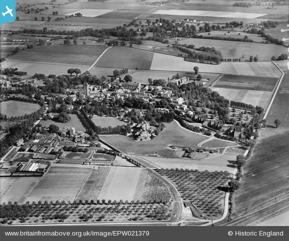
EPW021379 ENGLAND (1928). Napsbury Hospital. Napsbury, 1928
© Hawlfraint cyfranwyr OpenStreetMap a thrwyddedwyd gan yr OpenStreetMap Foundation. 2026. Trwyddedir y gartograffeg fel CC BY-SA.
Delweddau cyfagos (2)
EPW021379

EPW025391

Manylion
| Pennawd | [EPW021379] Napsbury Hospital. Napsbury, 1928 |
| Cyfeirnod | EPW021379 |
| Dyddiad | 30-May-1928 |
| Dolen | |
| Enw lle | NAPSBURY |
| Plwyf | LONDON COLNEY |
| Ardal | |
| Gwlad | ENGLAND |
| Dwyreiniad / Gogleddiad | 516467, 203981 |
| Hydred / Lledred | -0.31368698407884, 51.721983653569 |
| Cyfeirnod Grid Cenedlaethol | TL165040 |
Pinnau

John W |
Monday 13th of June 2016 05:23:43 PM | |
|
Chriss |
Sunday 3rd of January 2016 02:17:09 PM | |
During WW1, as mentioned by Mike Richardson, when the hospital was used as a military hospital a temporary platform was built here so that patients could be unloaded from hospital trains. |
John W |
Thursday 9th of March 2017 08:58:47 PM |
|
Mike Richardson |
Monday 24th of February 2014 11:40:55 AM | |
|
Mike Richardson |
Monday 24th of February 2014 11:35:02 AM |
Cyfraniadau Grŵp
View is approximately from the North-West side. |
John W |
Monday 13th of June 2016 05:20:12 PM |