
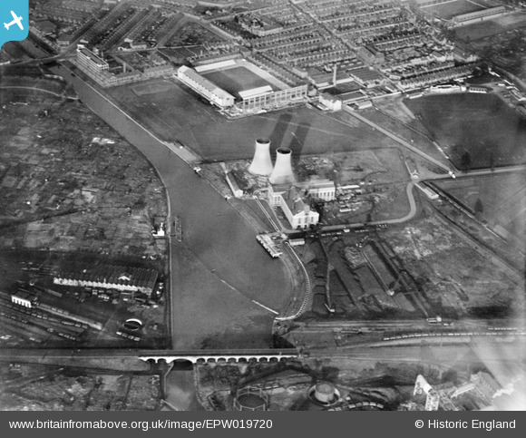
EPW019720 ENGLAND (1927). Power Station at Freeman's Wharf (now the site of the King Power Stadium) and environs, Leicester, 1927
© Hawlfraint cyfranwyr OpenStreetMap a thrwyddedwyd gan yr OpenStreetMap Foundation. 2026. Trwyddedir y gartograffeg fel CC BY-SA.
Delweddau cyfagos (15)
EPW019720
 and environs, Leicester, 1927")
EPW019717
, Leicester, 1927")
EPW019716
, Leicester, 1927")
EPW019719
 and environs, Leicester, 1927")
EPW019718
, Leicester, 1927")
EPW021006

EAW001143

EAW001136

EAW001140

EAW001137

EPW047635

EAW001142

EAW001138

EAW001141

EAW001139

Manylion
| Pennawd | [EPW019720] Power Station at Freeman's Wharf (now the site of the King Power Stadium) and environs, Leicester, 1927 |
| Cyfeirnod | EPW019720 |
| Dyddiad | October-1927 |
| Dolen | |
| Enw lle | LEICESTER |
| Plwyf | |
| Ardal | |
| Gwlad | ENGLAND |
| Dwyreiniad / Gogleddiad | 458097, 302954 |
| Hydred / Lledred | -1.141713901697, 52.620887188206 |
| Cyfeirnod Grid Cenedlaethol | SK581030 |
Pinnau

Class31 |
Sunday 10th of February 2013 09:46:23 PM | |
|
Class31 |
Sunday 10th of February 2013 05:55:13 PM | |
|
Class31 |
Sunday 10th of February 2013 05:53:27 PM | |
|
Class31 |
Sunday 10th of February 2013 05:50:54 PM | |
|
Class31 |
Sunday 10th of February 2013 05:47:25 PM |