
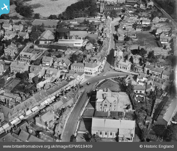
EPW019409 ENGLAND (1927). Bank Square, Wilmslow, 1927
© Hawlfraint cyfranwyr OpenStreetMap a thrwyddedwyd gan yr OpenStreetMap Foundation. 2026. Trwyddedir y gartograffeg fel CC BY-SA.
Delweddau cyfagos (5)
EPW019409

EPW019406

EAW016085

EPW019405

EAW016086

Manylion
| Pennawd | [EPW019409] Bank Square, Wilmslow, 1927 |
| Cyfeirnod | EPW019409 |
| Dyddiad | September-1927 |
| Dolen | |
| Enw lle | WILMSLOW |
| Plwyf | |
| Ardal | |
| Gwlad | ENGLAND |
| Dwyreiniad / Gogleddiad | 384738, 381229 |
| Hydred / Lledred | -2.2291763578902, 53.327488217845 |
| Cyfeirnod Grid Cenedlaethol | SJ847812 |
Pinnau

Roger |
Thursday 2nd of March 2017 08:57:59 AM | |
|
Roger |
Thursday 2nd of March 2017 08:56:48 AM | |
|
Roger |
Thursday 2nd of March 2017 08:56:01 AM | |
|
Roger |
Thursday 2nd of March 2017 08:55:30 AM | |
|
Roger |
Thursday 2nd of March 2017 08:54:33 AM | |
|
Roger |
Thursday 2nd of March 2017 08:53:53 AM | |
|
Roger |
Thursday 2nd of March 2017 08:53:27 AM | |
|
Roger |
Thursday 2nd of March 2017 08:52:32 AM | |
|
Roger |
Friday 2nd of October 2015 07:19:00 PM | |
|
totoro |
Saturday 7th of July 2012 10:59:19 PM | |
that is what locals call sparrow park the police station and court was next door and has since been demolished to be replaced by flats |
steve pullen |
Sunday 23rd of August 2015 08:36:38 PM |
sparrow park as it was known as locally was paved over in the 80s to house the market which used to be held where waitrose is now.the police station is the building next door built in 1900.this has since been demolished and flats have been built on the site.they look like KGB headquarters |
steve pullen |
Saturday 23rd of January 2016 11:08:51 PM |
|
totoro |
Saturday 7th of July 2012 10:55:05 PM | |
|
totoro |
Saturday 7th of July 2012 10:53:44 PM | |
|
totoro |
Saturday 7th of July 2012 10:50:40 PM | |
The sale to Santander fell through. The sale of the English branches of RBS to somebody remains a commitment. |
totoro |
Sunday 19th of January 2014 11:36:39 AM |
|
totoro |
Saturday 7th of July 2012 10:49:58 PM | |
|
totoro |
Saturday 7th of July 2012 10:46:09 PM | |
|
totoro |
Saturday 7th of July 2012 10:44:04 PM | |
|
totoro |
Saturday 7th of July 2012 10:43:45 PM | |
|
totoro |
Saturday 7th of July 2012 10:40:20 PM | |
|
totoro |
Saturday 7th of July 2012 10:39:32 PM | |
|
totoro |
Saturday 7th of July 2012 10:37:42 PM | |
|
totoro |
Saturday 7th of July 2012 10:37:20 PM | |
|
totoro |
Saturday 7th of July 2012 10:36:52 PM |
Cyfraniadau Grŵp
This photo is taken looking more or less to the North towards Manchester. |
totoro |
Saturday 7th of July 2012 11:02:01 PM |