
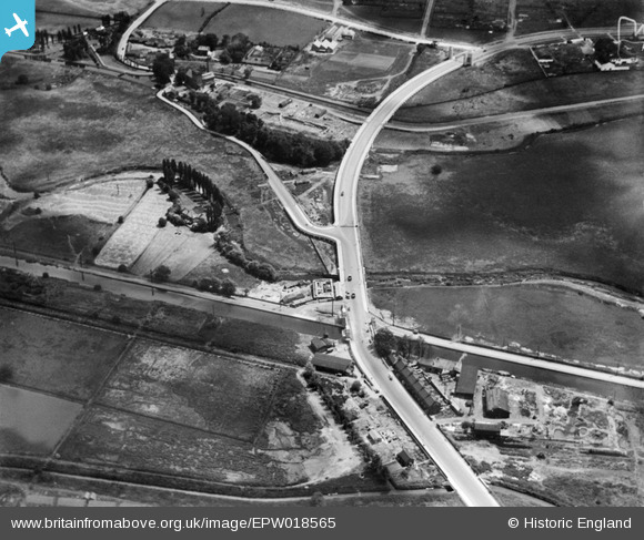
EPW018565 ENGLAND (1927). Cook's Ferry Public House and the Lea Valley Viaduct and environs, Edmonton, 1927
© Hawlfraint cyfranwyr OpenStreetMap a thrwyddedwyd gan yr OpenStreetMap Foundation. 2026. Trwyddedir y gartograffeg fel CC BY-SA.
Delweddau cyfagos (21)
EPW018565

EPW018567

EPW049703

EPW049529

EPW052282

EPW056321

EPW049710

EPW056823

EPW053837

EPW056816

EPW056818

EPW052271

EPW052272

EPW050859

EPW049711

EPW018568

EPW058457

EPW056320

EPW055981

EPW058467

EPW053836

Manylion
| Pennawd | [EPW018565] Cook's Ferry Public House and the Lea Valley Viaduct and environs, Edmonton, 1927 |
| Cyfeirnod | EPW018565 |
| Dyddiad | June-1927 |
| Dolen | |
| Enw lle | EDMONTON |
| Plwyf | |
| Ardal | |
| Gwlad | ENGLAND |
| Dwyreiniad / Gogleddiad | 535929, 192295 |
| Hydred / Lledred | -0.036611705428029, 51.612581921386 |
| Cyfeirnod Grid Cenedlaethol | TQ359923 |
Pinnau

john ruscoe |
Monday 14th of July 2014 12:48:03 AM | |
|
john ruscoe |
Monday 14th of July 2014 12:47:59 AM |
Cyfraniadau Grŵp
Cottages in foreground, my friend lived in just before they where knocked down to make way for the new A406 in the 90's. Opposite is a saw mill which is still there. The road that goes of to the left leads to a water pumping station that is still there, now behind a Mercedes dealership. |
SilentFart |
Tuesday 26th of June 2012 10:57:11 PM |
Cooks Ferry pub |
SilentFart |
Tuesday 26th of June 2012 10:52:51 PM |