
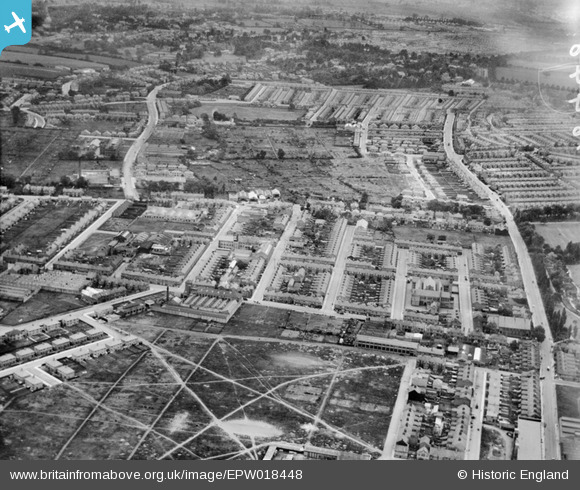
EPW018448 ENGLAND (1927). North Evington, Leicester, from the north-east, 1927
© Hawlfraint cyfranwyr OpenStreetMap a thrwyddedwyd gan yr OpenStreetMap Foundation. 2026. Trwyddedir y gartograffeg fel CC BY-SA.
Delweddau cyfagos (4)
EPW018448

EPW018472

EPW018473

EPW018655

Manylion
| Pennawd | [EPW018448] North Evington, Leicester, from the north-east, 1927 |
| Cyfeirnod | EPW018448 |
| Dyddiad | June-1927 |
| Dolen | |
| Enw lle | LEICESTER |
| Plwyf | |
| Ardal | |
| Gwlad | ENGLAND |
| Dwyreiniad / Gogleddiad | 461038, 304468 |
| Hydred / Lledred | -1.0979914393214, 52.63417484034 |
| Cyfeirnod Grid Cenedlaethol | SK610045 |
Pinnau

diag |
Monday 28th of October 2013 05:03:46 PM | |
|
diag |
Sunday 27th of October 2013 04:49:23 PM | |
|
diag |
Sunday 27th of October 2013 04:48:25 PM | |
|
diag |
Sunday 27th of October 2013 04:47:04 PM | |
|
diag |
Sunday 27th of October 2013 04:44:34 PM | |
|
diag |
Sunday 27th of October 2013 04:42:13 PM | |
|
diag |
Sunday 27th of October 2013 04:40:55 PM | |

Class31 |
Sunday 10th of February 2013 05:27:33 PM | |
|
Class31 |
Sunday 10th of February 2013 05:26:11 PM | |
|
Class31 |
Sunday 10th of February 2013 05:25:28 PM | |
|
Class31 |
Sunday 10th of February 2013 05:24:58 PM | |
|
Class31 |
Sunday 10th of February 2013 05:24:07 PM | |
|
Class31 |
Sunday 10th of February 2013 05:23:40 PM | |
|
Class31 |
Sunday 10th of February 2013 05:21:18 PM | |
|
Class31 |
Sunday 10th of February 2013 05:20:38 PM | |
|
Rebecca |
Thursday 10th of January 2013 05:46:26 PM | |
Thanks for all your contributions, Rebecca. |
David Parry |
Friday 25th of January 2013 12:54:57 PM |
|
Rebecca |
Thursday 10th of January 2013 05:45:33 PM | |
|
Rebecca |
Thursday 10th of January 2013 05:38:08 PM | |
|
Rebecca |
Thursday 10th of January 2013 05:37:36 PM | |
|
Rebecca |
Thursday 10th of January 2013 05:36:18 PM | |
|
Rebecca |
Thursday 10th of January 2013 05:33:58 PM | |
|
Rebecca |
Thursday 10th of January 2013 05:32:01 PM | |
|
Rebecca |
Thursday 10th of January 2013 05:31:25 PM | |
|
Rebecca |
Thursday 10th of January 2013 05:30:00 PM | |
|
Rebecca |
Thursday 10th of January 2013 05:29:36 PM | |
|
Rebecca |
Thursday 10th of January 2013 05:29:12 PM | |
|
Rebecca |
Thursday 10th of January 2013 05:28:37 PM | |
|
Rebecca |
Thursday 10th of January 2013 05:26:01 PM | |
Spelling correction : Osmaston |
diag |
Sunday 1st of September 2013 11:03:26 AM |
|
Rebecca |
Thursday 10th of January 2013 05:22:35 PM | |
|
Rebecca |
Thursday 10th of January 2013 05:21:10 PM | |
|
Rebecca |
Thursday 10th of January 2013 05:18:13 PM | |
|
Rebecca |
Thursday 10th of January 2013 05:16:58 PM | |
|
Rebecca |
Thursday 10th of January 2013 05:16:13 PM | |
|
Rebecca |
Thursday 10th of January 2013 05:15:39 PM | |
|
Rebecca |
Thursday 10th of January 2013 05:06:58 PM | |
|
Rebecca |
Thursday 10th of January 2013 05:05:58 PM | |
|
Rebecca |
Thursday 10th of January 2013 05:04:12 PM | |
|
Rebecca |
Thursday 10th of January 2013 05:03:30 PM | |
|
Rebecca |
Thursday 10th of January 2013 05:02:08 PM | |
|
Rebecca |
Thursday 10th of January 2013 04:59:53 PM | |
|
Rebecca |
Thursday 10th of January 2013 04:52:16 PM | |
|
Rebecca |
Thursday 10th of January 2013 04:30:38 PM | |
|
Birstall |
Wednesday 19th of December 2012 10:26:24 PM | |
|
Birstall |
Wednesday 19th of December 2012 10:23:16 PM | |
|
Birstall |
Wednesday 19th of December 2012 10:22:44 PM | |
|
Birstall |
Wednesday 19th of December 2012 10:21:59 PM | |
|
Birstall |
Wednesday 19th of December 2012 10:11:51 PM | |
|
JH |
Wednesday 3rd of October 2012 08:24:44 PM | |
|
JH |
Wednesday 3rd of October 2012 08:24:05 PM | |
|
Class31 |
Sunday 5th of August 2012 09:03:06 PM | |
|
Class31 |
Sunday 5th of August 2012 09:02:29 PM | |
|
Class31 |
Sunday 5th of August 2012 08:59:24 PM | |
|
Class31 |
Sunday 5th of August 2012 08:57:24 PM | |
|
Class31 |
Sunday 5th of August 2012 08:56:24 PM | |
|
Class31 |
Sunday 5th of August 2012 08:55:32 PM | |
|
Class31 |
Sunday 5th of August 2012 08:54:08 PM | |
|
Class31 |
Sunday 5th of August 2012 08:54:07 PM | |
|
Shortcut Ben |
Thursday 12th of July 2012 01:41:03 PM | |
|
Shortcut Ben |
Thursday 12th of July 2012 01:39:28 PM | |
|
Shortcut Ben |
Thursday 12th of July 2012 01:37:47 PM | |
Hi Shortcut Ben, That’s great; we’ve reviewed your identification and thanks to your help we can update the catalogue. The revised record will appear here in due course. Yours, Katy Britain from Above Cataloguing Team Leader |
Katy Whitaker |
Wednesday 24th of October 2012 08:58:15 AM |
|
SteveAUS |
Tuesday 3rd of July 2012 06:41:06 AM | |
|
EastMarple1 |
Saturday 30th of June 2012 12:16:58 PM | |
|
EastMarple1 |
Saturday 30th of June 2012 12:15:29 PM | |
|
BigglesH |
Thursday 28th of June 2012 10:13:27 PM |
Cyfraniadau Grŵp
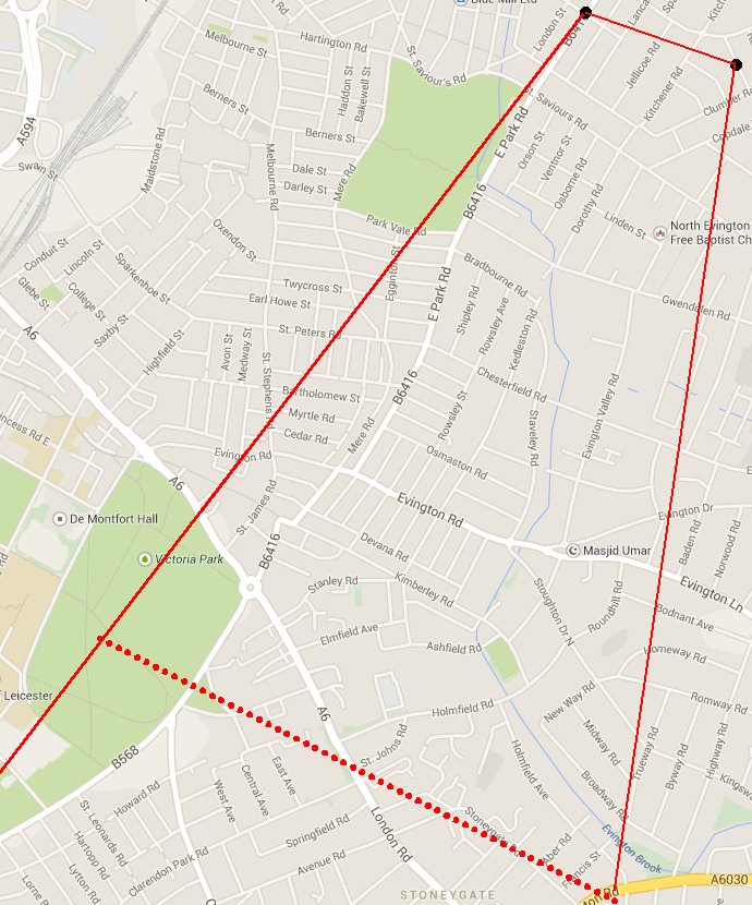
EPW018448 map ref |
steve.pyrah |
Sunday 10th of August 2014 02:14:11 PM |
Google Maps images of location: http://goo.gl/maps/zBCs SB |
Shortcut Ben |
Thursday 12th of July 2012 01:47:01 PM |
Located - Spinney Hills, Leicester, England |
Shortcut Ben |
Thursday 12th of July 2012 01:36:34 PM |
Only a few shadows visible; light seems to be from left and high in the sky, implying photo is looking west. |
BigglesH |
Thursday 28th of June 2012 10:20:43 PM |