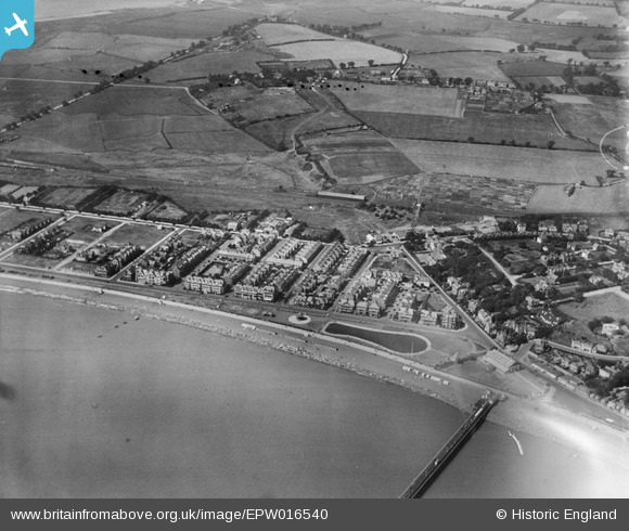
EPW016540 ENGLAND (1926). The Model Yacht Pond and Sea Road area, Felixstowe, 1926
    © Hawlfraint cyfranwyr OpenStreetMap a thrwyddedwyd gan yr OpenStreetMap Foundation. 2025. Trwyddedir y gartograffeg fel CC BY-SA.
  
Delweddau cyfagos (6)
Manylion
| Pennawd | [EPW016540] The Model Yacht Pond and Sea Road area, Felixstowe, 1926 | 
| Cyfeirnod | EPW016540 | 
| Dyddiad | August-1926 | 
| Dolen | |
| Enw lle | FELIXSTOWE | 
| Plwyf | FELIXSTOWE | 
| Ardal | |
| Gwlad | ENGLAND | 
| Dwyreiniad / Gogleddiad | 629618, 234025 | 
| Hydred / Lledred | 1.3422963242685, 51.956787430649 | 
| Cyfeirnod Grid Cenedlaethol | TM296340 | 
Pinnau
|   Ashbarrett | Tuesday 26th of June 2012 11:49:38 AM | 
 
             
  ![[EPW016540] The Model Yacht Pond and Sea Road area, Felixstowe, 1926](http://britainfromabove.org.uk/sites/all/libraries/aerofilms-images/public/100x100/EPW/016/EPW016540.jpg) 
  
                                          ![[EPW001922] View of Felixstowe and the New Pier, Felixstowe, from the west, 1920](http://britainfromabove.org.uk/sites/all/libraries/aerofilms-images/public/100x100/EPW/001/EPW001922.jpg) 
 ![[EPW001920] View of Felixstowe and the New Pier, Felixstowe, 1920](http://britainfromabove.org.uk/sites/all/libraries/aerofilms-images/public/100x100/EPW/001/EPW001920.jpg) 
 ![[EPW001918] The Q Tower and New Pier, Felixstowe, 1920](http://britainfromabove.org.uk/sites/all/libraries/aerofilms-images/public/100x100/EPW/001/EPW001918.jpg) 
 ![[EAW024305] The pier, Felixstowe, from the north-west, 1949](http://britainfromabove.org.uk/sites/all/libraries/aerofilms-images/public/100x100/EAW/024/EAW024305.jpg) 
 ![[EPW039284] Sea Road, the Model Yacht Pond and the town, Felixstowe, from the south-west, 1932](http://britainfromabove.org.uk/sites/all/libraries/aerofilms-images/public/100x100/EPW/039/EPW039284.jpg) 
 
 70 Langer Road Felixstowe (Built 1923, but not appearing in 1926 photo)
 70 Langer Road Felixstowe (Built 1923, but not appearing in 1926 photo)