
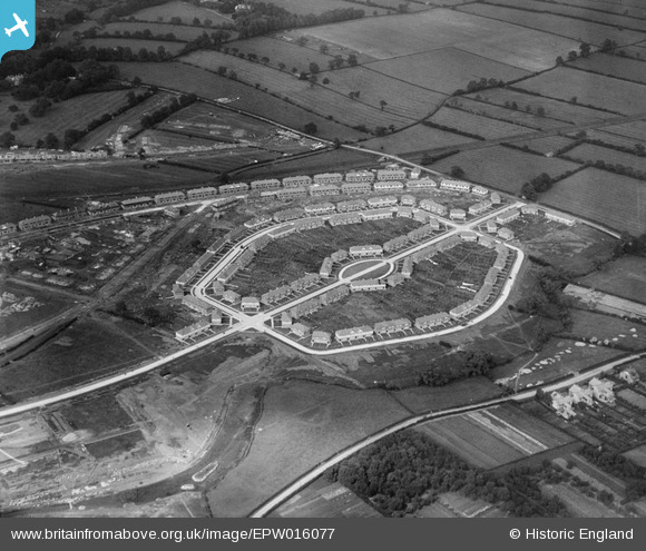
EPW016077 ENGLAND (1926). Housing estate aound Alcuin Avenue, York, 1926
© Hawlfraint cyfranwyr OpenStreetMap a thrwyddedwyd gan yr OpenStreetMap Foundation. 2026. Trwyddedir y gartograffeg fel CC BY-SA.
Delweddau cyfagos (10)
EPW016077

EPW015711

EPW016078

EPW015712

EPW015710

EPW016079

EPW016115

EPW016076

EPW016111

EPW015709

Manylion
| Pennawd | [EPW016077] Housing estate aound Alcuin Avenue, York, 1926 |
| Cyfeirnod | EPW016077 |
| Dyddiad | 30-June-1926 |
| Dolen | |
| Enw lle | YORK |
| Plwyf | |
| Ardal | |
| Gwlad | ENGLAND |
| Dwyreiniad / Gogleddiad | 462237, 451706 |
| Hydred / Lledred | -1.0513960255199, 53.957498526335 |
| Cyfeirnod Grid Cenedlaethol | SE622517 |
Pinnau

Joelybean |
Friday 30th of June 2017 04:48:15 PM | |
|
Joelybean |
Friday 30th of June 2017 04:35:11 PM | |
|
Gavin Thomas |
Monday 16th of July 2012 05:59:17 PM | |
|
Gavin Thomas |
Monday 16th of July 2012 05:55:19 PM | |
So glad I came across this view, sadly the house of Mr Bellerby (Burnholme Social Club ) is due to be demolished within the next few weeks, end of an era, I will no longer be able to watch the Birds trying to land on the Spire. |
Chris Lee |
Tuesday 11th of November 2014 03:08:11 PM |