
EPW015928 ENGLAND (1926). Irby Hill and Arrowe Park, Irby Hill, from the west, 1926

© Hawlfraint cyfranwyr OpenStreetMap a thrwyddedwyd gan yr OpenStreetMap Foundation. 2026. Trwyddedir y gartograffeg fel CC BY-SA.
Manylion
| Pennawd | [EPW015928] Irby Hill and Arrowe Park, Irby Hill, from the west, 1926 |
| Cyfeirnod | EPW015928 |
| Dyddiad | June-1926 |
| Dolen | |
| Enw lle | IRBY HILL |
| Plwyf | |
| Ardal | |
| Gwlad | ENGLAND |
| Dwyreiniad / Gogleddiad | 325534, 385945 |
| Hydred / Lledred | -3.119189756961, 53.364856869293 |
| Cyfeirnod Grid Cenedlaethol | SJ255859 |
Pinnau

Bunn72 |
Thursday 6th of February 2014 09:43:34 PM | |
|
Bunn72 |
Thursday 6th of February 2014 09:43:07 PM | |
|
Bunn72 |
Thursday 6th of February 2014 09:42:08 PM | |
|
Bunn72 |
Thursday 6th of February 2014 09:41:40 PM | |
|
Bunn72 |
Thursday 6th of February 2014 09:40:37 PM | |
|
Steve |
Thursday 6th of February 2014 02:47:07 PM | |
|
Steve |
Thursday 6th of February 2014 02:46:01 PM | |
|
Steve |
Thursday 6th of February 2014 02:44:47 PM | |
|
Steve |
Thursday 6th of February 2014 02:42:03 PM | |
|
BruceR |
Monday 22nd of October 2012 01:00:13 PM | |
|
BruceR |
Monday 22nd of October 2012 12:58:38 PM |
Cyfraniadau Grŵp
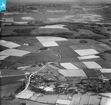
Another one of the Irby area. No sign of the cricket club but there seems to be some sort of holiday camp on the other side of the road. Bell tents and swings. |
BruceR |
Monday 22nd of October 2012 01:02:51 PM |