
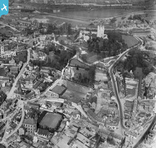
EPW014865 ENGLAND (1926). The Castle and environs, Conisbrough, 1926

© Hawlfraint cyfranwyr OpenStreetMap a thrwyddedwyd gan yr OpenStreetMap Foundation. 2026. Trwyddedir y gartograffeg fel CC BY-SA.
Delweddau cyfagos (9)
EPW014865

EPW014867

EPW012956

EPW015389

EPW014866

EAW005020

EAW005018

EAW005017

EAW005016

Manylion
| Pennawd | [EPW014865] The Castle and environs, Conisbrough, 1926 |
| Cyfeirnod | EPW014865 |
| Dyddiad | 5-April-1926 |
| Dolen | |
| Enw lle | CONISBROUGH |
| Plwyf | |
| Ardal | |
| Gwlad | ENGLAND |
| Dwyreiniad / Gogleddiad | 451365, 398685 |
| Hydred / Lledred | -1.2258877339008, 53.482123876778 |
| Cyfeirnod Grid Cenedlaethol | SK514987 |
Pinnau
Cyfraniadau Grŵp
The Castle, Conisbrough |

Robert - Cumbria |
Wednesday 27th of June 2012 09:03:19 PM |
Built in the 1180's by hamelin plantagenet. One of the finest examples of a norman keep. I remember this when the old steps were there and no roof on it as it is today. |
JulieW |
Wednesday 27th of June 2012 09:00:39 PM |
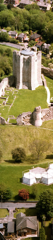
The castle as it is today |
JulieW |
Wednesday 27th of June 2012 09:03:19 PM |