
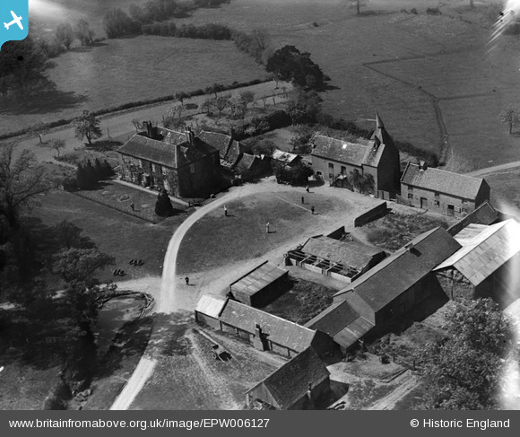
EPW006127 ENGLAND (1921). Brockbury Hall, Colwall, 1921
© Hawlfraint cyfranwyr OpenStreetMap a thrwyddedwyd gan yr OpenStreetMap Foundation. 2026. Trwyddedir y gartograffeg fel CC BY-SA.
Delweddau cyfagos (2)
EPW006127

EPW005390

Manylion
| Pennawd | [EPW006127] Brockbury Hall, Colwall, 1921 |
| Cyfeirnod | EPW006127 |
| Dyddiad | April-1921 |
| Dolen | |
| Enw lle | COLWALL |
| Plwyf | COLWALL |
| Ardal | |
| Gwlad | ENGLAND |
| Dwyreiniad / Gogleddiad | 374540, 241800 |
| Hydred / Lledred | -2.3715093146823, 52.073562398165 |
| Cyfeirnod Grid Cenedlaethol | SO745418 |
Pinnau

SteveAUS |
Tuesday 3rd of July 2012 06:02:26 AM | |
|
EastMarple1 |
Saturday 30th of June 2012 10:21:28 AM | |
|
EastMarple1 |
Saturday 30th of June 2012 10:19:49 AM | |
Herefordshire is a hop grwoing area, too. Buildings known as hop kilns here, not oast houses. |
VCH Herefordshire |
Thursday 9th of August 2012 02:21:34 PM |
Cyfraniadau Grŵp
I think it is Brockbury Hall - Most of the buildings fit as do most of the hedge rows although some of them are parch marks on Google earth rather than the hedges. The angle of the track going off to the left seems to have changed as part of the field combining process |
Dave Brunt |
Tuesday 23rd of October 2012 01:05:20 PM |
Thanks Dave, along with the other shot of this location your correct information means that we can update the catalogue. You may be interested to know that the original Aerofilms Ltd Register entries for the pair put them in Malvern. The revised records will be posted in due course. Yours, Katy Britain from Above Cataloguing Team Leader |
Katy Whitaker |
Tuesday 23rd of October 2012 01:05:20 PM |
is this not the same farm as EPWO05390? |
dave43 |
Saturday 4th of August 2012 09:53:59 PM |

Some nice waves to the plane here |
SteveAUS |
Tuesday 3rd of July 2012 06:03:00 AM |
Wonderful farmyard scene with the workers possibly watching the plane. Would love to know what this place looks like today. |
wiylee |
Friday 29th of June 2012 04:51:08 PM |