
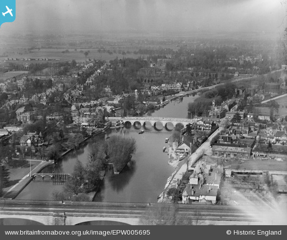
EPW005695 ENGLAND (1921). View of the town and Maidenhead Bridge, Maidenhead, from the south-east, 1921
© Hawlfraint cyfranwyr OpenStreetMap a thrwyddedwyd gan yr OpenStreetMap Foundation. 2026. Trwyddedir y gartograffeg fel CC BY-SA.
Delweddau cyfagos (16)
EPW005695

EPW022619

EPW056581

EPW022710

EAW021598

EPW022721

EAW013948

EAW003666

EAW013949

EAW021597

EPW056582

EAW029470

EAW003664

EAW026482

EAW021599

EAW021596

Manylion
| Pennawd | [EPW005695] View of the town and Maidenhead Bridge, Maidenhead, from the south-east, 1921 |
| Cyfeirnod | EPW005695 |
| Dyddiad | March-1921 |
| Dolen | |
| Enw lle | MAIDENHEAD |
| Plwyf | |
| Ardal | |
| Gwlad | ENGLAND |
| Dwyreiniad / Gogleddiad | 490176, 181169 |
| Hydred / Lledred | -0.70010390564108, 51.521749499081 |
| Cyfeirnod Grid Cenedlaethol | SU902812 |
Pinnau

misterjohn |
Sunday 1st of January 2023 04:27:06 PM | |

fern |
Sunday 8th of March 2020 06:13:04 PM | |
|
fern |
Sunday 8th of March 2020 06:11:08 PM | |
|
fern |
Sunday 8th of March 2020 06:10:19 PM | |
|
GrahamT |
Tuesday 18th of December 2012 09:22:21 PM | |

Class31 |
Tuesday 30th of October 2012 04:34:58 PM | |
|
Class31 |
Tuesday 30th of October 2012 04:34:06 PM | |
|
Class31 |
Tuesday 30th of October 2012 04:33:31 PM |