
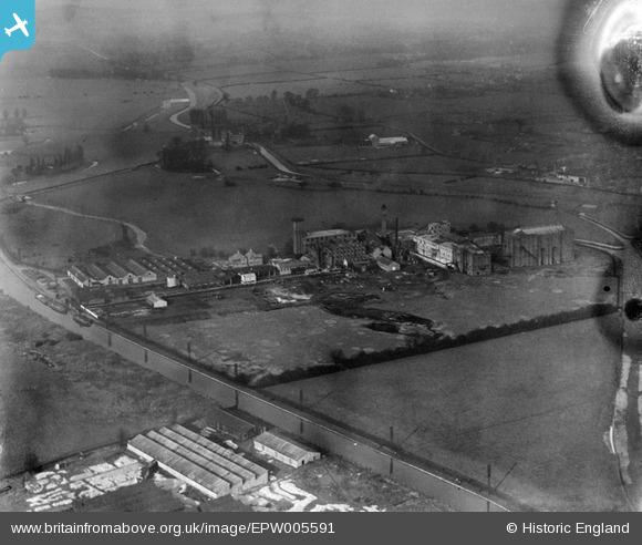
EPW005591 ENGLAND (1921). The Angel Road Linoleum Works, Edmonton, 1921
© Hawlfraint cyfranwyr OpenStreetMap a thrwyddedwyd gan yr OpenStreetMap Foundation. 2026. Trwyddedir y gartograffeg fel CC BY-SA.
Delweddau cyfagos (11)
EPW005591

EPW042086

EPW042085

EPW052284

EPW052265

EPW053853

EPW053856

EPW052688

EPW049521

EPW049520

EPW052272

Manylion
| Pennawd | [EPW005591] The Angel Road Linoleum Works, Edmonton, 1921 |
| Cyfeirnod | EPW005591 |
| Dyddiad | March-1921 |
| Dolen | |
| Enw lle | EDMONTON |
| Plwyf | |
| Ardal | |
| Gwlad | ENGLAND |
| Dwyreiniad / Gogleddiad | 535939, 191878 |
| Hydred / Lledred | -0.036629094119083, 51.608831905644 |
| Cyfeirnod Grid Cenedlaethol | TQ359919 |
Pinnau

BigglesH |
Friday 7th of September 2012 07:13:27 PM | |
I suspect it has to do with the manufacturing or drying process for linoleum, which appears to involve hanging it up. The taller the room, the longer length that can be hung. E.g. see http://www.michaelportillo.co.uk/articles/art_nipress/lino.htm |
Tony D |
Wednesday 12th of September 2012 09:36:44 AM |
|
martyk |
Tuesday 21st of August 2012 11:53:30 AM | |
|
martyk |
Tuesday 21st of August 2012 11:35:43 AM | |
A 1914/1915 map marks this as the "Angel Road Works (Linoleum ...)". I believe it was a linoleum factory belonging to Ridley, Whitley and Co. |
Tony D |
Tuesday 21st of August 2012 02:04:05 PM |
Hi Tony D, Thanks, it is the Angel Road Works. We can update the catalogue and the revised record with the correct location will appear here in due course. There was no subject information for this image in the original Aerofilms Ltd Register. Yours, Katy Britain from Above Cataloguing Team Leader |
Katy Whitaker |
Tuesday 23rd of October 2012 12:45:33 PM |
We have martyk to thank for this one. It was a good spot - the reservoirs have really changed the look of the area. |
Tony D |
Tuesday 23rd of October 2012 09:20:50 PM |
|
martyk |
Tuesday 21st of August 2012 11:34:13 AM | |
|
HydeParkDave |
Monday 16th of July 2012 11:17:37 PM | |
|
HydeParkDave |
Monday 16th of July 2012 11:15:02 PM | |
|
HydeParkDave |
Monday 16th of July 2012 11:12:48 PM | |
|
Tiny Tim |
Monday 16th of July 2012 03:14:52 PM |
Cyfraniadau Grŵp
ANGEL LINOLEUM WORKS.ANGEL ROAD.N18. |
mickml1953 |
Friday 26th of October 2012 08:37:46 PM |
Was R.A.F. Cardington (Balloon centre). The large 'shed' middle right was the Balloon hangar. The buildings between it and the canal were for making Gas. Haven't been near for many years but believe I'm correct. |
BigglesH |
Monday 2nd of July 2012 07:44:10 PM |
I am sorry but I don't agree. I served at RAF Cardington for nearly 3 years in the late 1980s (it has since been turned into a housing estate). The landscape is all wrong, Cardington was not close to canals and the nearest river the Ouse was about a mile away. The two massive airship hangars still stand, but are not depicted here. The main administration block also still stands, but is not depicted here. There was another large structure behind the administration block, since demolished but it is not depicted here. I have consulted an OS map of the area from 1919-20 and 1986 and they confirm that the canal and river system shown in this picture are not at Cardington. |
Mark |
Monday 2nd of July 2012 07:44:10 PM |