
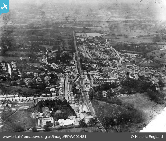
EPW001481 ENGLAND (1920). General view of the town, Crawley, from the east, 1920
© Hawlfraint cyfranwyr OpenStreetMap a thrwyddedwyd gan yr OpenStreetMap Foundation. 2026. Trwyddedir y gartograffeg fel CC BY-SA.
Delweddau cyfagos (10)
EPW001481

EPW028574

EAW041928

EPW001485

EPW028572

EPW028569

EAW037052

EPW001483

EAW011066

EPW028573

Manylion
| Pennawd | [EPW001481] General view of the town, Crawley, from the east, 1920 |
| Cyfeirnod | EPW001481 |
| Dyddiad | June-1920 |
| Dolen | |
| Enw lle | CRAWLEY |
| Plwyf | |
| Ardal | |
| Gwlad | ENGLAND |
| Dwyreiniad / Gogleddiad | 526674, 136414 |
| Hydred / Lledred | -0.19012960283309, 51.112472591889 |
| Cyfeirnod Grid Cenedlaethol | TQ267364 |
Pinnau

Helen |
Friday 22nd of May 2020 09:47:09 PM | |
|
Alpineblond |
Tuesday 2nd of August 2016 10:30:19 PM | |

Class31 |
Thursday 1st of November 2012 08:48:22 PM | |
|
Class31 |
Thursday 1st of November 2012 08:47:29 PM | |
|
Class31 |
Thursday 1st of November 2012 08:46:55 PM | |
|
Class31 |
Thursday 1st of November 2012 08:45:56 PM | |
|
Class31 |
Thursday 1st of November 2012 08:45:04 PM | |
|
Class31 |
Thursday 1st of November 2012 08:44:30 PM |
Cyfraniadau Grŵp

Crawley town, station and goods yard. |
tomoliver |
Saturday 1st of September 2012 05:43:45 PM |