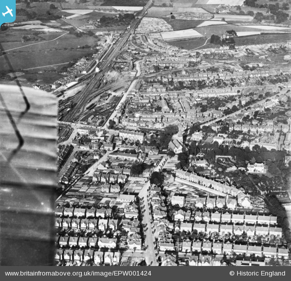
EPW001424 ENGLAND (1920). St Stephen's Church and the town, Tonbridge, 1920. This image has been produced from a print.
© Hawlfraint cyfranwyr OpenStreetMap a thrwyddedwyd gan yr OpenStreetMap Foundation. 2026. Trwyddedir y gartograffeg fel CC BY-SA.
Delweddau cyfagos (7)
Manylion
| Pennawd | [EPW001424] St Stephen's Church and the town, Tonbridge, 1920. This image has been produced from a print. |
| Cyfeirnod | EPW001424 |
| Dyddiad | 8-June-1920 |
| Dolen | |
| Enw lle | TONBRIDGE |
| Plwyf | |
| Ardal | |
| Gwlad | ENGLAND |
| Dwyreiniad / Gogleddiad | 558672, 145903 |
| Hydred / Lledred | 0.27088382636606, 51.189774435872 |
| Cyfeirnod Grid Cenedlaethol | TQ587459 |
Pinnau

eckypeck |
Monday 8th of February 2021 02:05:24 PM |


![[EPW001424] St Stephen's Church and the town, Tonbridge, 1920. This image has been produced from a print.](http://britainfromabove.org.uk/sites/all/libraries/aerofilms-images/public/100x100/EPW/001/EPW001424.jpg)
![[EPW062776] Meadow Lawn, Tonbridge, from the south-east, 1939](http://britainfromabove.org.uk/sites/all/libraries/aerofilms-images/public/100x100/EPW/062/EPW062776.jpg)
![[EPW001418] Tonbridge Railway Station, Tonbridge, 1920](http://britainfromabove.org.uk/sites/all/libraries/aerofilms-images/public/100x100/EPW/001/EPW001418.jpg)
![[EPW062775] Meadow Lawn, Tonbridge, from the south-east, 1939](http://britainfromabove.org.uk/sites/all/libraries/aerofilms-images/public/100x100/EPW/062/EPW062775.jpg)
![[EPW060388] Quarter Hill Road, St Mary's Road, the railway station and the town, Tonbridge, 1939](http://britainfromabove.org.uk/sites/all/libraries/aerofilms-images/public/100x100/EPW/060/EPW060388.jpg)
![[EPW001420] Barden Road looking towards Tonbridge Station, Tonbridge, 1920. This image has been produced from a print.](http://britainfromabove.org.uk/sites/all/libraries/aerofilms-images/public/100x100/EPW/001/EPW001420.jpg)
![[EPW060386] Quarter Hill Road, St Mary's Road, the railway station and the town, Tonbridge, 1939](http://britainfromabove.org.uk/sites/all/libraries/aerofilms-images/public/100x100/EPW/060/EPW060386.jpg)