
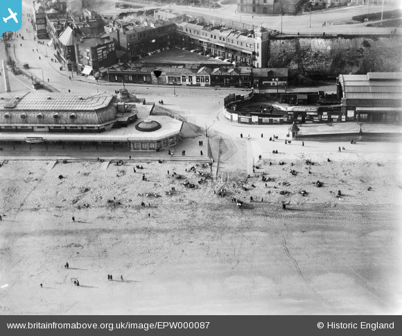
EPW000087 ENGLAND (1920). Ramsgate Harbour Station, Ramsgate, 1920
© Hawlfraint cyfranwyr OpenStreetMap a thrwyddedwyd gan yr OpenStreetMap Foundation. 2026. Trwyddedir y gartograffeg fel CC BY-SA.
Delweddau cyfagos (48)
EPW000087

EPW039325

EPW009172

EPW009173

EPW035453

EAW024843

EAW006169

EAW009051

EPW039324

EAW009056

EAW009058

EAW024842

EAW006166

EPW000093

EAW009014

EAW024844

EPW009174

EPW042859

EPW048783

EAW006170

EAW009057

EAW006171

EPW042864

EAW009054

EPW018649

EAW009015

EPW000096

EPW042861

EPW000599

EAW017591

EAW006168

EPW009175

EAW009052

EAW009049

EPW035450

EPW039353

EPW000092

EPW000596

EAW009055

EPW035449

EAW009005

EAW006165

EAW006164

EAW015836

EPW000604

EPW018646

EAW020486

EAW009006

Manylion
| Pennawd | [EPW000087] Ramsgate Harbour Station, Ramsgate, 1920 |
| Cyfeirnod | EPW000087 |
| Dyddiad | February-1920 |
| Dolen | |
| Enw lle | RAMSGATE |
| Plwyf | RAMSGATE |
| Ardal | |
| Gwlad | ENGLAND |
| Dwyreiniad / Gogleddiad | 638639, 164785 |
| Hydred / Lledred | 1.4261298203946, 51.33149339705 |
| Cyfeirnod Grid Cenedlaethol | TR386648 |
Pinnau

yes |
Tuesday 14th of May 2024 01:28:26 AM | |
|
Gen_Hancock |
Thursday 9th of February 2017 11:56:37 AM | |
|
EZTD |
Wednesday 27th of June 2012 11:28:11 PM | |
|
EZTD |
Wednesday 27th of June 2012 10:03:03 PM |
Cyfraniadau Grŵp
The Army operated a Driver Training School in Ramsgate during World War 2. My Father was based there for 5 weeks. A member of the Ramsgate History Forum suggested that this School may have been located at the Railway Station. Perhaps it was at the disused Station featuring in the picture "Ramsgate Harbour Station". Can anyone verify this? |
Robbo |
Friday 27th of May 2016 08:53:09 AM |
People enjoying the beach at Ramsgate. Many seaside towns developed rapidly after the railway arrived there. See more images of the seaside from the English Heritage Archive collections on Heritage Explorer http://www.heritage-explorer.co.uk/web/he/imagebytheme.aspx?ctid=4 |
MM |
Thursday 21st of March 2013 09:36:56 AM |
Opened in 1863 as part of the Kent Coast Railway company's extension of its line from Herne Bay, it was conveniently situated for the seaside resort's beach, but it closed in 1926 after a reorganisation of railway lines in the Thanet area. |
Buzby9 |
Sunday 7th of October 2012 08:25:55 PM |