
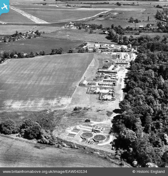
EAW043134 ENGLAND (1952). RAF Hunsdon Dispersed Site 1, Hunsdon, 1952.
© Hawlfraint cyfranwyr OpenStreetMap a thrwyddedwyd gan yr OpenStreetMap Foundation. 2026. Trwyddedir y gartograffeg fel CC BY-SA.
Delweddau cyfagos (9)
EAW043134

EAW043129

EAW043132

EAW043128

EAW043130

EAW043127

EAW043131

EAW043125

EAW043133

Manylion
| Pennawd | [EAW043134] RAF Hunsdon Dispersed Site 1, Hunsdon, 1952. |
| Cyfeirnod | EAW043134 |
| Dyddiad | 21-May-1952 |
| Dolen | |
| Enw lle | HUNSDON |
| Plwyf | HUNSDON |
| Ardal | |
| Gwlad | ENGLAND |
| Dwyreiniad / Gogleddiad | 541066, 213514 |
| Hydred / Lledred | 0.046126624684292, 51.802002010604 |
| Cyfeirnod Grid Cenedlaethol | TL411135 |
Pinnau

Matt Aldred edob.mattaldred.com |
Sunday 21st of June 2020 12:25:27 PM | |
|
Matt Aldred edob.mattaldred.com |
Sunday 21st of June 2020 12:25:09 PM | |
|
Matt Aldred edob.mattaldred.com |
Sunday 21st of June 2020 12:25:01 PM | |

Al |
Monday 17th of November 2014 10:22:05 PM | |
|
Al |
Monday 17th of November 2014 10:15:51 PM | |
|
Al |
Monday 17th of November 2014 10:14:51 PM | |
|
Al |
Monday 17th of November 2014 10:13:30 PM | |
|
Al |
Monday 17th of November 2014 10:13:14 PM | |
|
ewnmcg |
Thursday 6th of November 2014 06:23:21 PM | |
|
ewnmcg |
Tuesday 4th of November 2014 09:18:10 AM | |
|
ewnmcg |
Monday 3rd of November 2014 09:27:13 PM | |
|
ewnmcg |
Monday 3rd of November 2014 07:03:50 PM | |
|
ewnmcg |
Monday 3rd of November 2014 07:02:29 PM | |
|
ewnmcg |
Monday 3rd of November 2014 06:55:16 PM | |
|
ewnmcg |
Monday 3rd of November 2014 06:54:52 PM | |
|
ewnmcg |
Monday 3rd of November 2014 06:53:50 PM |

Cyfraniadau Grŵp

RAF Hunsdon, several WWII structures including 6 unrecorded (now removed) blast shelters |
Al |
Monday 17th of November 2014 10:23:15 PM |
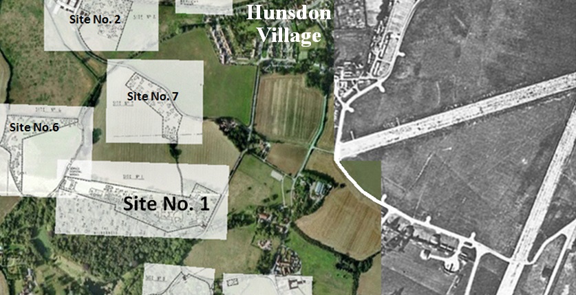
This is a composite image based on two images - one showing the runways and one showing some of the dispersal sites. No.1 site is shown with a larger font than the others. The largish distances from the airfield make sense - i.e. the runways and hangars would have been 'easy' targets and bomb blasts there could have impacted on accommodation sites. |
ewnmcg |
Monday 3rd of November 2014 10:08:17 PM |
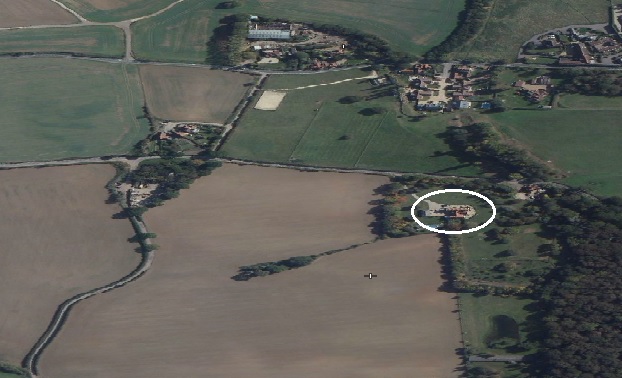
This is a very approximate 'aerial' view as of 'today'. It has been created using FLASHEARTH and then 'squashing' the image. Thus, it does not have the same proportions as the 1952 image. The 'circled' large house now occupies the site where the Sergeants mess once was. |
ewnmcg |
Monday 3rd of November 2014 08:57:27 PM |
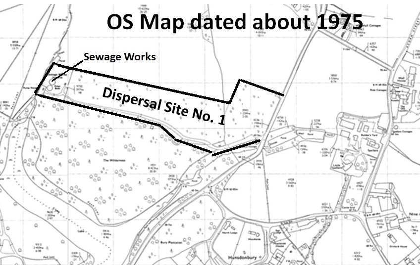
The dispersal site No. 1 as it appears in a map dated about 1975 |
ewnmcg |
Monday 3rd of November 2014 08:43:45 PM |
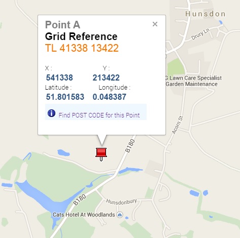
I think (repeat think) the attached Grid Ref is close enough. |
ewnmcg |
Monday 3rd of November 2014 06:51:48 PM |
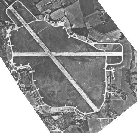
This shows the layout of the runways at RAF Hunsdon and it has been rotated to match the Image. |
ewnmcg |
Monday 3rd of November 2014 06:50:58 PM |
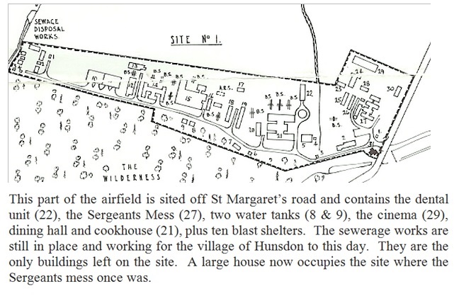
This is dispersal site No. 1 for RAF Hunsdon, Herts. This site lies off St Margaret’s road and contains the dental unit (22), the Sergeants Mess (27), two water tanks (8 & 9), the cinema (29), dining hall and cookhouse (21), plus ten blast shelters. The sewerage works are still in place and working for the village of Hunsdon to this day. They are the only buildings left on the site. A large house now occupies the site where the Sergeants mess once was. |
ewnmcg |
Monday 3rd of November 2014 06:49:12 PM |