
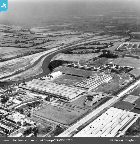
EAW038710 ENGLAND (1951). The International Harvester Factory off Wheatley Hall Road and environs, Doncaster, from the south-west, 1951. This image has been produced from a print.
© Hawlfraint cyfranwyr OpenStreetMap a thrwyddedwyd gan yr OpenStreetMap Foundation. 2026. Trwyddedir y gartograffeg fel CC BY-SA.
Delweddau cyfagos (16)
EAW038710

 0°
0m
0°
0m
EAW038712
 150°
35m
150°
35m
EAW038717
 8°
88m
8°
88m
EAW027266
 339°
105m
339°
105m
EAW038718
 46°
111m
46°
111m
EAW038713
 45°
119m
45°
119m
EAW038709
 357°
126m
357°
126m
EAW038708
 12°
127m
12°
127m
EAW038714
 346°
134m
346°
134m
EAW027263
 32°
163m
32°
163m
EAW038716
 38°
183m
38°
183m
EAW027261
 20°
185m
20°
185m
EAW027262
 11°
208m
11°
208m
EAW027268
 24°
218m
24°
218m
EAW027260
 358°
229m
358°
229m
EAW027264
 37°
255m
37°
255m
Manylion
| Pennawd | [EAW038710] The International Harvester Factory off Wheatley Hall Road and environs, Doncaster, from the south-west, 1951. This image has been produced from a print. |
| Cyfeirnod | EAW038710 |
| Dyddiad | 14-August-1951 |
| Dolen | |
| Enw lle | DONCASTER |
| Plwyf | |
| Ardal | |
| Gwlad | ENGLAND |
| Dwyreiniad / Gogleddiad | 459290, 405518 |
| Hydred / Lledred | -1.1051734806232, 53.542708063433 |
| Cyfeirnod Grid Cenedlaethol | SE593055 |
 2ndWW camouflage paint scheme.