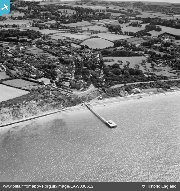
EAW038612 ENGLAND (1951). The pier and village, Totland, 1951
    © Hawlfraint cyfranwyr OpenStreetMap a thrwyddedwyd gan yr OpenStreetMap Foundation. 2025. Trwyddedir y gartograffeg fel CC BY-SA.
  
Delweddau cyfagos (5)
Manylion
| Pennawd | [EAW038612] The pier and village, Totland, 1951 | 
| Cyfeirnod | EAW038612 | 
| Dyddiad | 13-August-1951 | 
| Dolen | |
| Enw lle | TOTLAND | 
| Plwyf | TOTLAND | 
| Ardal | |
| Gwlad | ENGLAND | 
| Dwyreiniad / Gogleddiad | 432327, 87099 | 
| Hydred / Lledred | -1.5423771116848, 50.682070710388 | 
| Cyfeirnod Grid Cenedlaethol | SZ323871 | 
Pinnau
Byddwch y cyntaf i ychwanegu sylw at y ddelwedd hon!
 
             
  ![[EAW038612] The pier and village, Totland, 1951](http://britainfromabove.org.uk/sites/all/libraries/aerofilms-images/public/100x100/EAW/038/EAW038612.jpg) 
  
                                          ![[EPW022969] The Totlandbay Hotel and the pier, Totland, 1928](http://britainfromabove.org.uk/sites/all/libraries/aerofilms-images/public/100x100/EPW/022/EPW022969.jpg) 
 ![[EPW022968] The pier and houses on the promenade, Totland, 1928](http://britainfromabove.org.uk/sites/all/libraries/aerofilms-images/public/100x100/EPW/022/EPW022968.jpg) 
 ![[EPW000477] Totland Pier, Totland, 1920](http://britainfromabove.org.uk/sites/all/libraries/aerofilms-images/public/100x100/EPW/000/EPW000477.jpg) 
 ![[EAW038613] Totland Pier and Colwell Bay, Totland, from the south-west, 1951. This image has been produced from a damaged negative.](http://britainfromabove.org.uk/sites/all/libraries/aerofilms-images/public/100x100/EAW/038/EAW038613.jpg)