
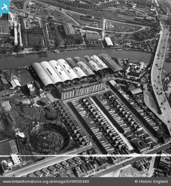
EAW035480 ENGLAND (1951). Oban Street, Moness Street, Portree Street and Commercial Wharf on the River Lea, South Bromley, 1951. This image has been produced from a print marked by Aerofilms Ltd for photo editing.
© Hawlfraint cyfranwyr OpenStreetMap a thrwyddedwyd gan yr OpenStreetMap Foundation. 2026. Trwyddedir y gartograffeg fel CC BY-SA.
Delweddau cyfagos (24)
EAW035480

EAW037185

EAW035483

EAW037183

EAW035484

EAW035482

EAW035477

EAW037181

EAW035481

EAW035478

EAW035479

EAW037180

EAW037177

EAW037184

EAW037179

EAW037186

EAW035489

EAW037178

EAW035487

EAW035485

EAW035490

EAW035492

EAW035504

EAW035502

Manylion
| Pennawd | [EAW035480] Oban Street, Moness Street, Portree Street and Commercial Wharf on the River Lea, South Bromley, 1951. This image has been produced from a print marked by Aerofilms Ltd for photo editing. |
| Cyfeirnod | EAW035480 |
| Dyddiad | 17-April-1951 |
| Dolen | |
| Enw lle | SOUTH BROMLEY |
| Plwyf | |
| Ardal | |
| Gwlad | ENGLAND |
| Dwyreiniad / Gogleddiad | 538910, 181479 |
| Hydred / Lledred | 0.0021433089689371, 51.514651825251 |
| Cyfeirnod Grid Cenedlaethol | TQ389815 |
Pinnau

Post-war prefabs |
Thursday 25th of February 2021 09:00:09 AM |