
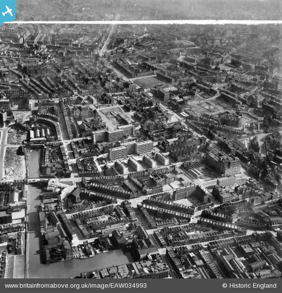
EAW034993 ENGLAND (1951). A cityscape over Pentonville, Islington, 1951. This image was marked by Aerofilms Ltd for photo editing.
© Hawlfraint cyfranwyr OpenStreetMap a thrwyddedwyd gan yr OpenStreetMap Foundation. 2026. Trwyddedir y gartograffeg fel CC BY-SA.
Delweddau cyfagos (36)
EAW034993

EAW044344

EAW034986

EAW044337

EAW044117

EAW044335

EAW034994

EAW044343

EAW034995

EAW034998

EAW034990

EAW044336

EAW044123

EAW044341

EAW044342

EAW044120

EAW044125

EAW034997

EAW044118

EAW034992

EAW044338

EAW044124

EPW032917

EAW044339

EAW044121

EAW044122

EAW035000

EAW044340

EAW034991

EAW034989

EAW034988

EAW044116

EPW021407

EAW044119

EAW034999

EAW044115

Manylion
| Pennawd | [EAW034993] A cityscape over Pentonville, Islington, 1951. This image was marked by Aerofilms Ltd for photo editing. |
| Cyfeirnod | EAW034993 |
| Dyddiad | 20-March-1951 |
| Dolen | |
| Enw lle | ISLINGTON |
| Plwyf | |
| Ardal | |
| Gwlad | ENGLAND |
| Dwyreiniad / Gogleddiad | 530803, 183210 |
| Hydred / Lledred | -0.11399185204293, 51.5321449458 |
| Cyfeirnod Grid Cenedlaethol | TQ308832 |
Pinnau

billyfern |
Saturday 14th of June 2014 12:42:15 PM | |
|
billyfern |
Saturday 14th of June 2014 12:41:35 PM | |
|
billyfern |
Saturday 14th of June 2014 12:41:11 PM | |
|
billyfern |
Saturday 14th of June 2014 12:40:50 PM | |
|
billyfern |
Saturday 14th of June 2014 12:40:20 PM | |
|
billyfern |
Saturday 14th of June 2014 12:39:48 PM | |
|
billyfern |
Saturday 14th of June 2014 12:39:04 PM | |
|
billyfern |
Saturday 14th of June 2014 12:38:39 PM | |
|
billyfern |
Saturday 14th of June 2014 12:38:09 PM | |
|
billyfern |
Saturday 14th of June 2014 12:37:46 PM | |
|
billyfern |
Saturday 14th of June 2014 12:37:26 PM | |
|
billyfern |
Saturday 14th of June 2014 12:36:57 PM | |
|
billyfern |
Saturday 14th of June 2014 12:36:33 PM | |
|
billyfern |
Saturday 14th of June 2014 12:36:07 PM | |
|
billyfern |
Saturday 14th of June 2014 12:34:31 PM | |
|
billyfern |
Saturday 14th of June 2014 12:34:09 PM | |
|
billyfern |
Saturday 14th of June 2014 12:33:42 PM | |
|
billyfern |
Saturday 14th of June 2014 12:33:22 PM | |
|
billyfern |
Saturday 14th of June 2014 12:32:51 PM | |
|
billyfern |
Saturday 14th of June 2014 12:32:29 PM | |
|
billyfern |
Saturday 14th of June 2014 12:32:13 PM | |
|
billyfern |
Saturday 14th of June 2014 12:32:01 PM | |
|
billyfern |
Saturday 14th of June 2014 12:31:45 PM | |
|
billyfern |
Saturday 14th of June 2014 12:31:21 PM | |
|
billyfern |
Saturday 14th of June 2014 12:30:54 PM | |
|
billyfern |
Saturday 14th of June 2014 12:30:32 PM |