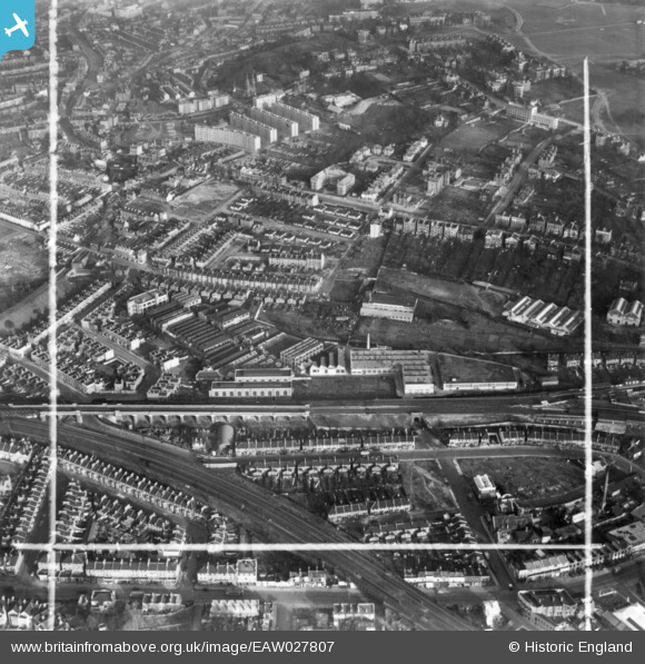
EAW027807 ENGLAND (1949). Elliott Brothers (London) Ltd Century Works (Electrical Engineering), Lewisham, 1949. This image has been produced from a print marked by Aerofilms Ltd for photo editing.
© Hawlfraint cyfranwyr OpenStreetMap a thrwyddedwyd gan yr OpenStreetMap Foundation. 2026. Trwyddedir y gartograffeg fel CC BY-SA.
Delweddau cyfagos (7)
Manylion
| Pennawd | [EAW027807] Elliott Brothers (London) Ltd Century Works (Electrical Engineering), Lewisham, 1949. This image has been produced from a print marked by Aerofilms Ltd for photo editing. |
| Cyfeirnod | EAW027807 |
| Dyddiad | 19-December-1949 |
| Dolen | |
| Enw lle | LEWISHAM |
| Plwyf | |
| Ardal | |
| Gwlad | ENGLAND |
| Dwyreiniad / Gogleddiad | 537959, 176176 |
| Hydred / Lledred | -0.013627811128936, 51.467226273748 |
| Cyfeirnod Grid Cenedlaethol | TQ380762 |
Pinnau

Post-war prefabs |
Monday 20th of March 2023 11:57:10 AM | |

Leslie B |
Saturday 3rd of December 2022 12:34:28 PM | |

Leslie B |
Friday 2nd of June 2017 09:35:22 PM | |

John Wass |
Friday 26th of June 2015 08:35:55 PM |


![[EAW027807] Elliott Brothers (London) Ltd Century Works (Electrical Engineering), Lewisham, 1949. This image has been produced from a print marked by Aerofilms Ltd for photo editing.](http://britainfromabove.org.uk/sites/all/libraries/aerofilms-images/public/100x100/EAW/027/EAW027807.jpg)
![[EAW027809] Elliott Brothers (London) Ltd Century Works (Electrical Engineering), Lewisham, 1949. This image was marked by Aerofilms Ltd for photo editing.](http://britainfromabove.org.uk/sites/all/libraries/aerofilms-images/public/100x100/EAW/027/EAW027809.jpg)
![[EAW027808] Elliott Brothers (London) Ltd Century Works (Electrical Engineering), Lewisham, 1949. This image has been produced from a print marked by Aerofilms Ltd for photo editing.](http://britainfromabove.org.uk/sites/all/libraries/aerofilms-images/public/100x100/EAW/027/EAW027808.jpg)
![[EAW027806] Elliott Brothers (London) Ltd Century Works (Electrical Engineering), Lewisham, 1949. This image has been produced from a print marked by Aerofilms Ltd for photo editing.](http://britainfromabove.org.uk/sites/all/libraries/aerofilms-images/public/100x100/EAW/027/EAW027806.jpg)
![[EAW027803] Elliott Brothers (London) Ltd Century Works (Electrical Engineering), Lewisham, 1949. This image was marked by Aerofilms Ltd for photo editing.](http://britainfromabove.org.uk/sites/all/libraries/aerofilms-images/public/100x100/EAW/027/EAW027803.jpg)
![[EAW027805] Elliott Brothers (London) Ltd Century Works (Electrical Engineering), Lewisham, 1949. This image has been produced from a print marked by Aerofilms Ltd for photo editing.](http://britainfromabove.org.uk/sites/all/libraries/aerofilms-images/public/100x100/EAW/027/EAW027805.jpg)
![[EAW027804] Elliott Brothers (London) Ltd Century Works (Electrical Engineering), Lewisham, 1949. This image has been produced from a damaged negative.](http://britainfromabove.org.uk/sites/all/libraries/aerofilms-images/public/100x100/EAW/027/EAW027804.jpg)