
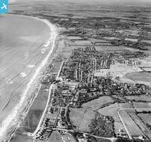
EAW019988 ENGLAND (1948). Barton Cliff, the village and Chewton Hill, Barton on Sea, from the east, 1948

© Hawlfraint cyfranwyr OpenStreetMap a thrwyddedwyd gan yr OpenStreetMap Foundation. 2026. Trwyddedir y gartograffeg fel CC BY-SA.
Delweddau cyfagos (3)
EAW019988

EPW018175

EPW037443

Manylion
| Pennawd | [EAW019988] Barton Cliff, the village and Chewton Hill, Barton on Sea, from the east, 1948 |
| Cyfeirnod | EAW019988 |
| Dyddiad | 19-October-1948 |
| Dolen | |
| Enw lle | BARTON ON SEA |
| Plwyf | NEW MILTON |
| Ardal | |
| Gwlad | ENGLAND |
| Dwyreiniad / Gogleddiad | 424164, 93102 |
| Hydred / Lledred | -1.6575373387875, 50.73645544874 |
| Cyfeirnod Grid Cenedlaethol | SZ242931 |
Pinnau

Matt Aldred edob.mattaldred.com |
Sunday 22nd of August 2021 03:27:47 PM | |

Class31 |
Thursday 12th of May 2016 08:19:51 AM | |

Al |
Tuesday 27th of May 2014 11:15:10 PM | |
|
Al |
Tuesday 27th of May 2014 11:13:25 PM |

Cyfraniadau Grŵp
unrecorded T22 |
Al |
Tuesday 27th of May 2014 11:14:08 PM |