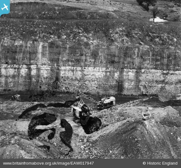
EAW017947 ENGLAND (1948). Opencast coal mining to the north of Carrington's Farm, Smalley, 1948. This image has been produced from a damaged negative.
    © Hawlfraint cyfranwyr OpenStreetMap a thrwyddedwyd gan yr OpenStreetMap Foundation. 2025. Trwyddedir y gartograffeg fel CC BY-SA.
  
Delweddau cyfagos (13)
Manylion
| Pennawd | [EAW017947] Opencast coal mining to the north of Carrington's Farm, Smalley, 1948. This image has been produced from a damaged negative. | 
| Cyfeirnod | EAW017947 | 
| Dyddiad | 10-August-1948 | 
| Dolen | |
| Enw lle | SMALLEY | 
| Plwyf | SMALLEY | 
| Ardal | |
| Gwlad | ENGLAND | 
| Dwyreiniad / Gogleddiad | 441395, 346101 | 
| Hydred / Lledred | -1.3829706350416, 53.010308361236 | 
| Cyfeirnod Grid Cenedlaethol | SK414461 | 
Pinnau
Byddwch y cyntaf i ychwanegu sylw at y ddelwedd hon!
Cyfraniadau Grŵp
| The pond and trees at the right background can also be seen in more detail on EAW011251 | Class31 | Saturday 4th of January 2014 08:59:11 PM | 
 
             
  ![[EAW017947] Opencast coal mining to the north of Carrington's Farm, Smalley, 1948. This image has been produced from a damaged negative.](http://britainfromabove.org.uk/sites/all/libraries/aerofilms-images/public/100x100/EAW/017/EAW017947.jpg) 
  
                                          ![[EAW017957] Opencast coal mining to the north of Carrington's Farm, Smalley, 1948. This image has been produced from a damaged negative.](http://britainfromabove.org.uk/sites/all/libraries/aerofilms-images/public/100x100/EAW/017/EAW017957.jpg) 
 ![[EAW017988] Opencast coal mining to the north of Kidsleypark Farm, Smalley, 1948. This image has been produced from a print.](http://britainfromabove.org.uk/sites/all/libraries/aerofilms-images/public/100x100/EAW/017/EAW017988.jpg) 
 ![[EAW017952] Opencast coal mining to the north of Kidsleypark Farm, Smalley, 1948. This image has been produced from a print.](http://britainfromabove.org.uk/sites/all/libraries/aerofilms-images/public/100x100/EAW/017/EAW017952.jpg) 
 ![[EAW017984] Opencast coal mining to the north of Kidsleypark Farm, Smalley, 1948. This image has been produced from a print.](http://britainfromabove.org.uk/sites/all/libraries/aerofilms-images/public/100x100/EAW/017/EAW017984.jpg) 
 ![[EAW017989] Opencast coal mining to the north of Kidsleypark Farm, Smalley, 1948. This image has been produced from a print.](http://britainfromabove.org.uk/sites/all/libraries/aerofilms-images/public/100x100/EAW/017/EAW017989.jpg) 
 ![[EAW017990] Opencast coal mining to the north of Kidsleypark Farm, Smalley, 1948. This image has been produced from a print.](http://britainfromabove.org.uk/sites/all/libraries/aerofilms-images/public/100x100/EAW/017/EAW017990.jpg) 
 ![[EAW017959] Opencast coal mining to the north of Carrington's Farm, Smalley, 1948. This image has been produced from a damaged negative.](http://britainfromabove.org.uk/sites/all/libraries/aerofilms-images/public/100x100/EAW/017/EAW017959.jpg) 
 ![[EAW017987] Opencast coal mining to the north of Kidsleypark Farm, Smalley, 1948. This image has been produced from a print.](http://britainfromabove.org.uk/sites/all/libraries/aerofilms-images/public/100x100/EAW/017/EAW017987.jpg) 
 ![[EAW011251] Disturbed land adjacent to an extensive area of opencast coal mining to the west of Kidsleypark Farm, Smalley, 1947](http://britainfromabove.org.uk/sites/all/libraries/aerofilms-images/public/100x100/EAW/011/EAW011251.jpg) 
 ![[EAW011228] Opencast coal mining around Dumbles Lane, Smalley, 1947](http://britainfromabove.org.uk/sites/all/libraries/aerofilms-images/public/100x100/EAW/011/EAW011228.jpg) 
 ![[EAW011221] Opencast coal mining to the east of Flamstead House, Smalley, 1947](http://britainfromabove.org.uk/sites/all/libraries/aerofilms-images/public/100x100/EAW/011/EAW011221.jpg) 
 ![[EAW011229] Opencast coal mining around Dumbles Lane, Smalley, 1947](http://britainfromabove.org.uk/sites/all/libraries/aerofilms-images/public/100x100/EAW/011/EAW011229.jpg)