
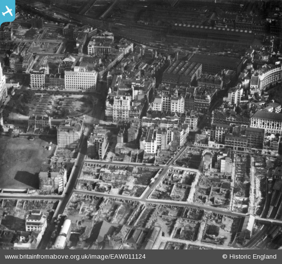
EAW011124 ENGLAND (1947). Cleared sites around Ropemaker Street following bomb damage, St Luke's, 1947. This image has been produced from a print.
© Hawlfraint cyfranwyr OpenStreetMap a thrwyddedwyd gan yr OpenStreetMap Foundation. 2026. Trwyddedir y gartograffeg fel CC BY-SA.
Delweddau cyfagos (8)
EAW011124

EPW053665

EPW053666

EAW000514

EAW011200

EAW011199

EAW011123

EAW011125

Manylion
| Pennawd | [EAW011124] Cleared sites around Ropemaker Street following bomb damage, St Luke's, 1947. This image has been produced from a print. |
| Cyfeirnod | EAW011124 |
| Dyddiad | 30-September-1947 |
| Dolen | |
| Enw lle | ST LUKE'S |
| Plwyf | |
| Ardal | |
| Gwlad | ENGLAND |
| Dwyreiniad / Gogleddiad | 532765, 181846 |
| Hydred / Lledred | -0.086233406392081, 51.51942803493 |
| Cyfeirnod Grid Cenedlaethol | TQ328818 |
Pinnau

brianbeckett |
Saturday 16th of May 2020 08:37:59 AM | |
|
S00Z |
Thursday 16th of March 2017 04:05:49 PM | |
|
S00Z |
Thursday 16th of March 2017 04:05:06 PM | |
|
billyfern |
Friday 3rd of October 2014 06:56:49 PM | |
|
billyfern |
Friday 3rd of October 2014 06:56:10 PM | |
|
billyfern |
Friday 3rd of October 2014 06:55:53 PM |