
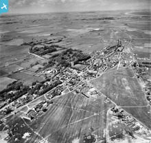
EAW006620 ENGLAND (1947). All Saints' Church and the town, Lydd, from the south, 1947

© Hawlfraint cyfranwyr OpenStreetMap a thrwyddedwyd gan yr OpenStreetMap Foundation. 2026. Trwyddedir y gartograffeg fel CC BY-SA.
Manylion
| Pennawd | [EAW006620] All Saints' Church and the town, Lydd, from the south, 1947 |
| Cyfeirnod | EAW006620 |
| Dyddiad | 27-May-1947 |
| Dolen | |
| Enw lle | LYDD |
| Plwyf | LYDD |
| Ardal | |
| Gwlad | ENGLAND |
| Dwyreiniad / Gogleddiad | 604180, 120643 |
| Hydred / Lledred | 0.90712304483758, 50.948457258047 |
| Cyfeirnod Grid Cenedlaethol | TR042206 |
Pinnau

Bob Labrax |
Monday 16th of December 2024 02:16:19 PM | |
|
redmist |
Saturday 4th of November 2023 02:10:40 PM | |

Matt Aldred edob.mattaldred.com |
Thursday 11th of March 2021 11:23:52 PM | |
|
Matt Aldred edob.mattaldred.com |
Thursday 11th of March 2021 11:23:19 PM | |
|
Matt Aldred edob.mattaldred.com |
Thursday 11th of March 2021 11:22:39 PM | |
|
Matt Aldred edob.mattaldred.com |
Thursday 11th of March 2021 11:22:24 PM | |

Sparky |
Thursday 6th of July 2017 12:16:37 AM | |
|
Mike Floate |
Tuesday 27th of May 2014 12:16:13 PM | |
|
cptpies |
Thursday 28th of November 2013 10:11:36 AM | |
|
cptpies |
Thursday 28th of November 2013 10:11:11 AM |
Cyfraniadau Grŵp
Nodal Point defences, Lydd. |
cptpies |
Thursday 19th of December 2013 01:53:24 PM |