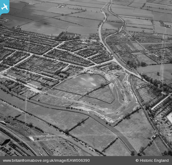
EAW006390 ENGLAND (1947). Housing on Welbeck Road under construction and the surrounding residential area, Long Eaton, 1947. This image was marked by Aerofilms Ltd for photo editing.
© Hawlfraint cyfranwyr OpenStreetMap a thrwyddedwyd gan yr OpenStreetMap Foundation. 2026. Trwyddedir y gartograffeg fel CC BY-SA.
Delweddau cyfagos (17)
Manylion
| Pennawd | [EAW006390] Housing on Welbeck Road under construction and the surrounding residential area, Long Eaton, 1947. This image was marked by Aerofilms Ltd for photo editing. |
| Cyfeirnod | EAW006390 |
| Dyddiad | 27-May-1947 |
| Dolen | |
| Enw lle | LONG EATON |
| Plwyf | |
| Ardal | |
| Gwlad | ENGLAND |
| Dwyreiniad / Gogleddiad | 448000, 335272 |
| Hydred / Lledred | -1.2861303094857, 52.912408725692 |
| Cyfeirnod Grid Cenedlaethol | SK480353 |
Pinnau

Dave_Hunt |
Friday 6th of March 2020 04:46:47 PM | |

Dave_Hunt |
Friday 6th of March 2020 04:44:46 PM | |

Dave_Hunt |
Friday 6th of March 2020 04:43:32 PM | |

Dave_Hunt |
Friday 6th of March 2020 04:42:54 PM | |

redmist |
Tuesday 18th of June 2019 08:12:50 PM | |

redmist |
Tuesday 18th of June 2019 08:06:48 PM |


![[EAW006390] Housing on Welbeck Road under construction and the surrounding residential area, Long Eaton, 1947. This image was marked by Aerofilms Ltd for photo editing.](http://britainfromabove.org.uk/sites/all/libraries/aerofilms-images/public/100x100/EAW/006/EAW006390.jpg)
![[EAW016178] The area between Longmoor Road and Toton Sidings, Long Eaton, 1948. This image has been produced from a damaged negative.](http://britainfromabove.org.uk/sites/all/libraries/aerofilms-images/public/100x100/EAW/016/EAW016178.jpg)
![[EAW016180] Longmoor Primary School and houses along Welbeck Road under construction, Long Eaton, 1948. This image was marked by Aerofilms Ltd for photo editing.](http://britainfromabove.org.uk/sites/all/libraries/aerofilms-images/public/100x100/EAW/016/EAW016180.jpg)
![[EAW006391] Housing on Welbeck Road under construction and the surrounding residential area, Long Eaton, 1947. This image was marked by Aerofilms Ltd for photo editing.](http://britainfromabove.org.uk/sites/all/libraries/aerofilms-images/public/100x100/EAW/006/EAW006391.jpg)
![[EAW016186] New houses along Welbeck Road and environs, Long Eaton, from the south-east, 1948](http://britainfromabove.org.uk/sites/all/libraries/aerofilms-images/public/100x100/EAW/016/EAW016186.jpg)
![[EAW006387] Housing on Welbeck Road under construction and the surrounding residential area, Long Eaton, 1947. This image was marked by Aerofilms Ltd for photo editing.](http://britainfromabove.org.uk/sites/all/libraries/aerofilms-images/public/100x100/EAW/006/EAW006387.jpg)
![[EAW016183] Longmoor Primary School and houses along Welbeck Road under construction, Long Eaton, 1948](http://britainfromabove.org.uk/sites/all/libraries/aerofilms-images/public/100x100/EAW/016/EAW016183.jpg)
![[EAW016182] Longmoor Primary School and houses along Welbeck Road under construction, Long Eaton, from the north, 1948. This image was marked by Aerofilms Ltd for photo editing.](http://britainfromabove.org.uk/sites/all/libraries/aerofilms-images/public/100x100/EAW/016/EAW016182.jpg)
![[EAW006385] Housing on Welbeck Road under construction and the Toton Railway Sidings, Long Eaton, 1947. This image was marked by Aerofilms Ltd for photo editing.](http://britainfromabove.org.uk/sites/all/libraries/aerofilms-images/public/100x100/EAW/006/EAW006385.jpg)
![[EAW016181] Longmoor Primary School and houses along Welbeck Road under construction, Long Eaton, from the south, 1948. This image was marked by Aerofilms Ltd for photo editing.](http://britainfromabove.org.uk/sites/all/libraries/aerofilms-images/public/100x100/EAW/016/EAW016181.jpg)
![[EAW006388] Housing on Welbeck Road under construction, Long Eaton, 1947. This image was marked by Aerofilms Ltd for photo editing.](http://britainfromabove.org.uk/sites/all/libraries/aerofilms-images/public/100x100/EAW/006/EAW006388.jpg)
![[EAW006384] Housing on Welbeck Road under construction and the Toton Railway Sidings, Long Eaton, 1947](http://britainfromabove.org.uk/sites/all/libraries/aerofilms-images/public/100x100/EAW/006/EAW006384.jpg)
![[EAW016185] New houses along Welbeck Road and environs, Long Eaton, 1948](http://britainfromabove.org.uk/sites/all/libraries/aerofilms-images/public/100x100/EAW/016/EAW016185.jpg)
![[EAW006389] Housing on Welbeck Road under construction and housing off Margaret Avenue, Long Eaton, 1947. This image was marked by Aerofilms Ltd for photo editing.](http://britainfromabove.org.uk/sites/all/libraries/aerofilms-images/public/100x100/EAW/006/EAW006389.jpg)
![[EAW006386] Housing on Welbeck Road under construction and housing off Victor Crescent, Long Eaton, 1947. This image was marked by Aerofilms Ltd for photo editing.](http://britainfromabove.org.uk/sites/all/libraries/aerofilms-images/public/100x100/EAW/006/EAW006386.jpg)
![[EAW016179] Longmoor Primary School and houses along Welbeck Road under construction, Long Eaton, 1948. This image was marked by Aerofilms Ltd for photo editing.](http://britainfromabove.org.uk/sites/all/libraries/aerofilms-images/public/100x100/EAW/016/EAW016179.jpg)
![[EAW016184] The Erewash Canal and houses along Welbeck Road under construction, Long Eaton, 1948](http://britainfromabove.org.uk/sites/all/libraries/aerofilms-images/public/100x100/EAW/016/EAW016184.jpg)