
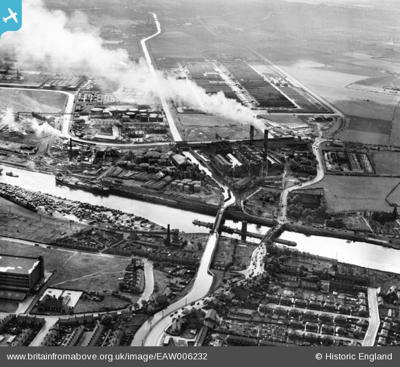
EAW006232 ENGLAND (1947). Barton Swing Aqueduct, Barton Power Station and environs, Trafford Park, 1947
© Hawlfraint cyfranwyr OpenStreetMap a thrwyddedwyd gan yr OpenStreetMap Foundation. 2026. Trwyddedir y gartograffeg fel CC BY-SA.
Delweddau cyfagos (9)
EAW006232

EPW031020

EPW027510

EPW027776

EAW006233

EPW041532

EAW006231

EAW006234

EAW006230

Manylion
| Pennawd | [EAW006232] Barton Swing Aqueduct, Barton Power Station and environs, Trafford Park, 1947 |
| Cyfeirnod | EAW006232 |
| Dyddiad | 25-May-1947 |
| Dolen | |
| Enw lle | TRAFFORD PARK |
| Plwyf | |
| Ardal | |
| Gwlad | ENGLAND |
| Dwyreiniad / Gogleddiad | 376876, 397486 |
| Hydred / Lledred | -2.3484230713246, 53.473344503719 |
| Cyfeirnod Grid Cenedlaethol | SJ769975 |
Pinnau

Ged |
Sunday 27th of March 2022 02:49:39 PM | |
|
redmist |
Sunday 6th of January 2019 09:15:32 PM | |

Sparky |
Wednesday 4th of October 2017 12:00:08 AM | |
|
Richard |
Tuesday 22nd of August 2017 06:59:52 PM | |
|
phloberts |
Saturday 12th of August 2017 08:27:45 PM | |
|
phloberts |
Saturday 12th of August 2017 08:26:17 PM | |
|
phloberts |
Saturday 12th of August 2017 08:21:41 PM | |
|
phloberts |
Saturday 12th of August 2017 08:19:30 PM | |
|
stardelta |
Wednesday 11th of June 2014 11:18:32 PM |