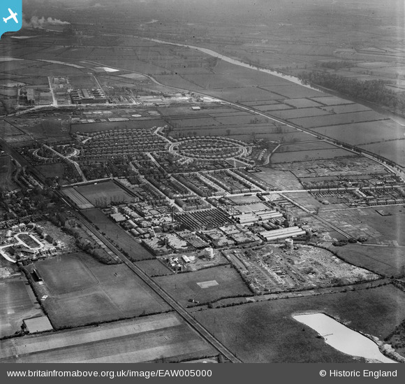
EAW005000 ENGLAND (1947). The Ericsson Telephone Works and the residential area surrounding Beech Avenue, Rylands, from the west, 1947
© Hawlfraint cyfranwyr OpenStreetMap a thrwyddedwyd gan yr OpenStreetMap Foundation. 2026. Trwyddedir y gartograffeg fel CC BY-SA.
Delweddau cyfagos (25)
Manylion
| Pennawd | [EAW005000] The Ericsson Telephone Works and the residential area surrounding Beech Avenue, Rylands, from the west, 1947 |
| Cyfeirnod | EAW005000 |
| Dyddiad | 7-May-1947 |
| Dolen | |
| Enw lle | RYLANDS |
| Plwyf | |
| Ardal | |
| Gwlad | ENGLAND |
| Dwyreiniad / Gogleddiad | 453095, 335795 |
| Hydred / Lledred | -1.2102779739101, 52.916630820324 |
| Cyfeirnod Grid Cenedlaethol | SK531358 |
Pinnau

Sparky |
Friday 6th of October 2017 11:03:48 PM |


![[EAW005000] The Ericsson Telephone Works and the residential area surrounding Beech Avenue, Rylands, from the west, 1947](http://britainfromabove.org.uk/sites/all/libraries/aerofilms-images/public/100x100/EAW/005/EAW005000.jpg)
![[EAW004243] The British Ericsson Telephone Works, Rylands Estate and environs, Beeston, from the west, 1947](http://britainfromabove.org.uk/sites/all/libraries/aerofilms-images/public/100x100/EAW/004/EAW004243.jpg)
![[EAW005001] The Ericsson Telephone Works and the residential area surrounding Beech Avenue, Rylands, from the south-west, 1947](http://britainfromabove.org.uk/sites/all/libraries/aerofilms-images/public/100x100/EAW/005/EAW005001.jpg)
![[EAW004246] The British Ericsson Telephone Works, Rylands Estate and environs, Beeston, from the west, 1947](http://britainfromabove.org.uk/sites/all/libraries/aerofilms-images/public/100x100/EAW/004/EAW004246.jpg)
![[EAW005006] The Ericsson Telephone Works and the residential area surrounding Beech Avenue, Rylands, from the west, 1947](http://britainfromabove.org.uk/sites/all/libraries/aerofilms-images/public/100x100/EAW/005/EAW005006.jpg)
![[EAW005005] The Ericsson Telephone Works, housing off Trent Road and the Chilwell Manor Golf Course, Rylands, 1947](http://britainfromabove.org.uk/sites/all/libraries/aerofilms-images/public/100x100/EAW/005/EAW005005.jpg)
![[EAW004245] The British Ericsson Telephone Works, Rylands Estate and environs, Beeston, from the north-west, 1947](http://britainfromabove.org.uk/sites/all/libraries/aerofilms-images/public/100x100/EAW/004/EAW004245.jpg)
![[EAW005002] The Ericsson Telephone Works and the residential area surrounding Beech Avenue, Rylands, from the south-west, 1947](http://britainfromabove.org.uk/sites/all/libraries/aerofilms-images/public/100x100/EAW/005/EAW005002.jpg)
![[EAW006377] The Ericsson Telephone Works, Rylands, 1947. This image was marked by Aerofilms Ltd for photo editing.](http://britainfromabove.org.uk/sites/all/libraries/aerofilms-images/public/100x100/EAW/006/EAW006377.jpg)
![[EAW004247] The British Ericsson Telephone Works, Rylands Estate and environs, Beeston, from the south-west, 1947. This image was marked by Aerofilms Ltd for photo editing.](http://britainfromabove.org.uk/sites/all/libraries/aerofilms-images/public/100x100/EAW/004/EAW004247.jpg)
![[EAW006378] The Ericsson Telephone Works, Rylands, 1947. This image was marked by Aerofilms Ltd for photo editing.](http://britainfromabove.org.uk/sites/all/libraries/aerofilms-images/public/100x100/EAW/006/EAW006378.jpg)
![[EAW006382] The Ericsson Telephone Works and the surrounding residential area, Rylands, 1947. This image was marked by Aerofilms Ltd for photo editing.](http://britainfromabove.org.uk/sites/all/libraries/aerofilms-images/public/100x100/EAW/006/EAW006382.jpg)
![[EAW005004] The Ericsson Telephone Works, Rylands, 1947](http://britainfromabove.org.uk/sites/all/libraries/aerofilms-images/public/100x100/EAW/005/EAW005004.jpg)
![[EPW053166] Ericsson Telephones Ltd Telephone Works, Rylands, 1937](http://britainfromabove.org.uk/sites/all/libraries/aerofilms-images/public/100x100/EPW/053/EPW053166.jpg)
![[EPW052431] The British Ericsson Telephone Works and environs, Beeston, 1937. This image has been produced from a copy-negative.](http://britainfromabove.org.uk/sites/all/libraries/aerofilms-images/public/100x100/EPW/052/EPW052431.jpg)
![[EAW004249] The British Ericsson Telephone Works and environs, Beeston, from the south-west, 1947](http://britainfromabove.org.uk/sites/all/libraries/aerofilms-images/public/100x100/EAW/004/EAW004249.jpg)
![[EAW006376] The Ericsson Telephone Works and the surrounding residential area, Rylands, 1947. This image was marked by Aerofilms Ltd for photo editing.](http://britainfromabove.org.uk/sites/all/libraries/aerofilms-images/public/100x100/EAW/006/EAW006376.jpg)
![[EAW005003] The Ericsson Telephone Works and the residential area surrounding Beech Avenue, Rylands, from the west, 1947](http://britainfromabove.org.uk/sites/all/libraries/aerofilms-images/public/100x100/EAW/005/EAW005003.jpg)
![[EAW004244] The British Ericsson Telephone Works and environs, Beeston, from the north-west, 1947](http://britainfromabove.org.uk/sites/all/libraries/aerofilms-images/public/100x100/EAW/004/EAW004244.jpg)
![[EAW004248] The British Ericsson Telephone Works, Rylands Estate and environs, Beeston, from the north-west, 1947. This image was marked by Aerofilms Ltd for photo editing.](http://britainfromabove.org.uk/sites/all/libraries/aerofilms-images/public/100x100/EAW/004/EAW004248.jpg)
![[EAW004239] The British Ericsson Telephone Works, Rylands Estate and environs, Beeston, from the south-west, 1947. This image was marked by Aerofilms Ltd for photo editing.](http://britainfromabove.org.uk/sites/all/libraries/aerofilms-images/public/100x100/EAW/004/EAW004239.jpg)
![[EAW004242] The British Ericsson Telephone Works and environs, Beeston, 1947. This image was marked by Aerofilms Ltd for photo editing.](http://britainfromabove.org.uk/sites/all/libraries/aerofilms-images/public/100x100/EAW/004/EAW004242.jpg)
![[EPW052424] The British Ericsson Telephone Works and environs, Beeston, 1937. This image has been produced from a copy-negative.](http://britainfromabove.org.uk/sites/all/libraries/aerofilms-images/public/100x100/EPW/052/EPW052424.jpg)
![[EPW053164] Ericsson Telephones Ltd Telephone Works, Rylands, 1937](http://britainfromabove.org.uk/sites/all/libraries/aerofilms-images/public/100x100/EPW/053/EPW053164.jpg)
![[EAW004240] The British Ericsson Telephone Works and environs, Beeston, from the south, 1947. This image was marked by Aerofilms Ltd for photo editing.](http://britainfromabove.org.uk/sites/all/libraries/aerofilms-images/public/100x100/EAW/004/EAW004240.jpg)