
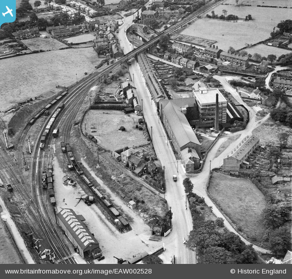
EAW002528 ENGLAND (1946). The J C Naylor & Co Ltd Emery Mills on Hyde Road and environs, Woodley, 1946
© Hawlfraint cyfranwyr OpenStreetMap a thrwyddedwyd gan yr OpenStreetMap Foundation. 2026. Trwyddedir y gartograffeg fel CC BY-SA.
Delweddau cyfagos (9)
EAW002528

 0°
0m
0°
0m
EAW002751
 307°
42m
307°
42m
EAW002531
 281°
46m
281°
46m
EAW002752
 301°
59m
301°
59m
EAW002527
 350°
65m
350°
65m
EAW002530
 341°
66m
341°
66m
EAW002529
 277°
123m
277°
123m
EAW002750
 294°
127m
294°
127m
EAW002753
 282°
174m
282°
174m
Manylion
| Pennawd | [EAW002528] The J C Naylor & Co Ltd Emery Mills on Hyde Road and environs, Woodley, 1946 |
| Cyfeirnod | EAW002528 |
| Dyddiad | 10-September-1946 |
| Dolen | |
| Enw lle | WOODLEY |
| Plwyf | |
| Ardal | |
| Gwlad | ENGLAND |
| Dwyreiniad / Gogleddiad | 393807, 392410 |
| Hydred / Lledred | -2.0932145343393, 53.42818515848 |
| Cyfeirnod Grid Cenedlaethol | SJ938924 |
Pinnau
 Distinctive flat fronted ex-military Bedford. Distinctive flat fronted ex-military Bedford. |

redmist |
Thursday 3rd of January 2019 03:18:38 PM |
| WW2 communal surface blast shelter. |
redmist |
Thursday 3rd of January 2019 09:55:02 AM |
| WW2 communal surface blast shelter. |
redmist |
Thursday 3rd of January 2019 09:53:59 AM |
| Advertising hoarding on railway bridge LOCKHEED |

Sparky |
Sunday 17th of September 2017 10:11:01 AM |
| WW2 Communal Surface Blast Shelter |
Sparky |
Sunday 17th of September 2017 10:10:11 AM |
| WW2 Emergency Water Supply EWS Painted Sign |
Sparky |
Sunday 17th of September 2017 10:09:28 AM |
| WW2 Communal Surface Blast Shelter |
Sparky |
Sunday 17th of September 2017 10:08:32 AM |
| This is now a housing estate |
totoro |
Tuesday 12th of November 2013 01:58:51 PM |
| Horse |
totoro |
Tuesday 12th of November 2013 01:58:29 PM |
| Woodley Methodist Church (since rebuilt) |
totoro |
Tuesday 12th of November 2013 01:52:38 PM |
| Pub Bowling Green |
totoro |
Tuesday 12th of November 2013 01:45:46 PM |
| The Navigation, a real ale pub with a bowling green in the back. |
totoro |
Tuesday 12th of November 2013 01:45:10 PM |
| Whoops! Looks like something not very pleasant happened here. |
Triggy |
Tuesday 12th of November 2013 01:39:35 PM |
| Bankfield Road |
totoro |
Tuesday 12th of November 2013 01:26:45 PM |
| Peak Forest Canal.
To the right of the picture is goes to Ashton where there is a junction and you can turn left for Manchester or right for Diggle and the Standedge Tunnel, and on to Huddersfield.
To left it passes to a large set of canal locks at Marple then on to Furness Vale and another junction - turn right for Macclesfield or left for Buxworth Basin. |
totoro |
Tuesday 12th of November 2013 01:25:40 PM |
| Railway Line. This section remains in place but is now used only for freight, serving a waste site and a concrete works both to the top. To the bottom the line passes through Woodley station towards Manchester.
At the time of this image the line was a through line going to the top to Stockport Tiviot Dale and on towards Manchester Central.
When originally built the line terminated to the top at Stockport Portwood but was extended in 1865. In 1980, motorway work in Stockport damaged the line there, it was closed and not reopened, leaving just the two small freight spurs in operation. |
totoro |
Tuesday 12th of November 2013 01:18:29 PM |
| Manor Road |
totoro |
Tuesday 12th of November 2013 01:16:50 PM |
| Hyde Road |
totoro |
Tuesday 12th of November 2013 01:15:43 PM |