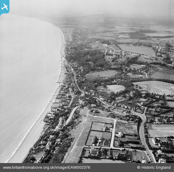
EAW002376 ENGLAND (1946). Sandgate Hill and environs, Folkestone, from the east, 1946
© Hawlfraint cyfranwyr OpenStreetMap a thrwyddedwyd gan yr OpenStreetMap Foundation. 2025. Trwyddedir y gartograffeg fel CC BY-SA.
Delweddau cyfagos (15)
Manylion
| Pennawd | [EAW002376] Sandgate Hill and environs, Folkestone, from the east, 1946 |
| Cyfeirnod | EAW002376 |
| Dyddiad | 9-September-1946 |
| Dolen | |
| Enw lle | FOLKESTONE |
| Plwyf | FOLKESTONE |
| Ardal | |
| Gwlad | ENGLAND |
| Dwyreiniad / Gogleddiad | 621224, 135376 |
| Hydred / Lledred | 1.1584002660936, 51.074465843777 |
| Cyfeirnod Grid Cenedlaethol | TR212354 |
Pinnau

redmist |
Sunday 16th of February 2025 10:37:40 AM | |

Paolo |
Friday 31st of July 2015 10:02:15 PM | |

Paolo |
Friday 31st of July 2015 10:01:28 PM | |

Paolo |
Tuesday 8th of July 2014 05:47:50 PM | |

Paolo |
Tuesday 8th of July 2014 05:46:36 PM | |

Paolo |
Tuesday 8th of July 2014 05:44:29 PM | |

Paolo |
Friday 6th of September 2013 12:11:53 PM | |
A house was constructed at the northern end of the trap, which was filled in after the war with scrap metal. Then the owner wondered why the 14 ton stone chimney drove the house into the ground! |

Paolo |
Wednesday 5th of February 2014 09:24:42 PM |


![[EAW002376] Sandgate Hill and environs, Folkestone, from the east, 1946](http://britainfromabove.org.uk/sites/all/libraries/aerofilms-images/public/100x100/EAW/002/EAW002376.jpg)
![[EPW035412] Martello Tower number 4, Radnor Cliff and the town, Folkestone, from the west, 1931](http://britainfromabove.org.uk/sites/all/libraries/aerofilms-images/public/100x100/EPW/035/EPW035412.jpg)
![[EAW002377] Sandgate Hill and environs, Folkestone, from the east, 1946](http://britainfromabove.org.uk/sites/all/libraries/aerofilms-images/public/100x100/EAW/002/EAW002377.jpg)
![[EPW019045] Fair in progress off Dixwell Road, Folkestone, 1927. This image has been produced from a print.](http://britainfromabove.org.uk/sites/all/libraries/aerofilms-images/public/100x100/EPW/019/EPW019045.jpg)
![[EPW026113] Sandgate Hill and Balfour Gardens, Folkestone, 1929](http://britainfromabove.org.uk/sites/all/libraries/aerofilms-images/public/100x100/EPW/026/EPW026113.jpg)
![[EAW032832] Martello Tower no. 4, Radnor Cliff Crescent and the seafront, Sandgate, from the east, 1950. This image was marked by Aerofilms Ltd for photo editing.](http://britainfromabove.org.uk/sites/all/libraries/aerofilms-images/public/100x100/EAW/032/EAW032832.jpg)
![[EAW032834] Martello Tower no. 4 and The Leas looking towards the town and harbour, Folkestone, from the south-west, 1950](http://britainfromabove.org.uk/sites/all/libraries/aerofilms-images/public/100x100/EAW/032/EAW032834.jpg)
![[EAW032835] Martello Tower no. 4 and The Leas, Folkestone, 1950](http://britainfromabove.org.uk/sites/all/libraries/aerofilms-images/public/100x100/EAW/032/EAW032835.jpg)
![[EAW032836] Radnor Cliff Crescent, Martello Tower no. 4 and environs, Sandgate, from the south, 1950. This image was marked by Aerofilms Ltd for photo editing.](http://britainfromabove.org.uk/sites/all/libraries/aerofilms-images/public/100x100/EAW/032/EAW032836.jpg)
![[EAW032833] Martello Tower no. 4, Radnor Cliff Crescent and environs, Folkestone, 1950. This image was marked by Aerofilms Ltd for photo editing.](http://britainfromabove.org.uk/sites/all/libraries/aerofilms-images/public/100x100/EAW/032/EAW032833.jpg)
![[EAW002860] Radnor Cliff, the seafront and the village, Sandgate, 1946](http://britainfromabove.org.uk/sites/all/libraries/aerofilms-images/public/100x100/EAW/002/EAW002860.jpg)
![[EPW042871] Radnor Cliff, The Leas and the town, Folkestone, from the south-west, 1933](http://britainfromabove.org.uk/sites/all/libraries/aerofilms-images/public/100x100/EPW/042/EPW042871.jpg)
![[EPW000585] Hotel Metropole, Coolinge, from the west, 1920](http://britainfromabove.org.uk/sites/all/libraries/aerofilms-images/public/100x100/EPW/000/EPW000585.jpg)
![[EAW002858] The village and the seafront, Sandgate, 1946](http://britainfromabove.org.uk/sites/all/libraries/aerofilms-images/public/100x100/EAW/002/EAW002858.jpg)
![[EPW026117] The village and seafront, Sandgate, 1929](http://britainfromabove.org.uk/sites/all/libraries/aerofilms-images/public/100x100/EPW/026/EPW026117.jpg)
