
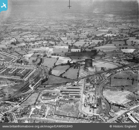
EAW001840 ENGLAND (1946). The Gas Works at Longford and the surrounding countryside, Longford, from the south-east, 1946
© Hawlfraint cyfranwyr OpenStreetMap a thrwyddedwyd gan yr OpenStreetMap Foundation. 2026. Trwyddedir y gartograffeg fel CC BY-SA.
Delweddau cyfagos (12)
EAW001840

 0°
0m
0°
0m
EPW027271
 266°
45m
266°
45m
EPW039608
 355°
121m
355°
121m
EPW039606
 188°
135m
188°
135m
EPW039609
 10°
139m
10°
139m
EPW039612
 10°
145m
10°
145m
EAW001842
 334°
177m
334°
177m
EAW001841
 327°
194m
327°
194m
EAW001837
 351°
231m
351°
231m
EAW001836
 22°
236m
22°
236m
EAW001839
 15°
242m
15°
242m
EAW001838
 360°
246m
360°
246m
Manylion
| Pennawd | [EAW001840] The Gas Works at Longford and the surrounding countryside, Longford, from the south-east, 1946 |
| Cyfeirnod | EAW001840 |
| Dyddiad | 12-July-1946 |
| Dolen | |
| Enw lle | LONGFORD |
| Plwyf | |
| Ardal | |
| Gwlad | ENGLAND |
| Dwyreiniad / Gogleddiad | 434510, 283115 |
| Hydred / Lledred | -1.4922139857697, 52.444535175459 |
| Cyfeirnod Grid Cenedlaethol | SP345831 |
Pinnau
 2ndWW Surface Blast Shelter. 2ndWW Surface Blast Shelter. |

redmist |
Saturday 29th of October 2022 08:58:48 PM |
| 38 Farndale Avenue |
Davethefish |
Tuesday 6th of October 2020 11:33:43 PM |
| Bedlam Gates Level Crossing (Bedlam Lane) |
Darren |
Saturday 20th of April 2019 02:39:13 AM |
| WW2 Camouflage Scheme |

Sparky |
Tuesday 8th of August 2017 08:17:06 AM |
| Bedlam Lane |
Tezzacov |
Tuesday 11th of February 2014 06:04:46 PM |
| Peggy's Field/Park |
Tezzacov |
Tuesday 11th of February 2014 06:03:04 PM |
| Coventry Canal |
Tezzacov |
Tuesday 11th of February 2014 05:59:25 PM |
| Dovedale/Rivali/Ritz Cinema |
Tezzacov |
Tuesday 11th of February 2014 05:54:47 PM |
|
Dean |
Friday 15th of November 2013 02:53:12 PM | |
| Steam locomotive |
MB |
Sunday 6th of October 2013 06:36:31 PM |
