
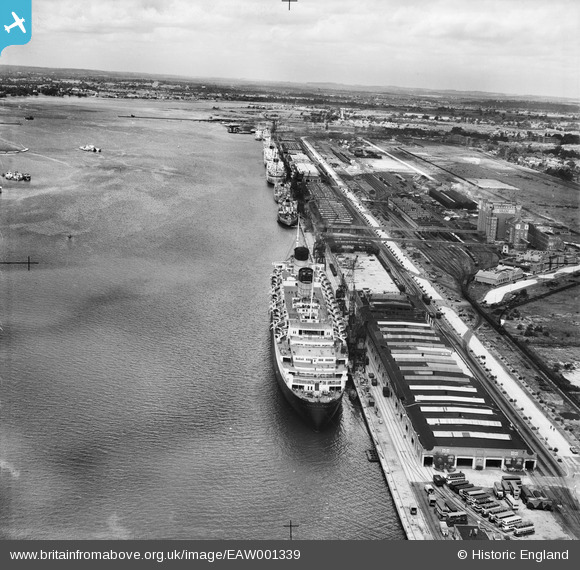
EAW001339 ENGLAND (1946). RMS Queen Elizabeth at the New Docks (Western Docks), Southampton, from the south-east, 1946
© Hawlfraint cyfranwyr OpenStreetMap a thrwyddedwyd gan yr OpenStreetMap Foundation. 2026. Trwyddedir y gartograffeg fel CC BY-SA.
Delweddau cyfagos (25)
EAW001339
, Southampton, from the south-east, 1946")
EAW001362
, Southampton, 1946")
EAW001363
, Southampton, from the south-west, 1946")
EAW001364
, Southampton, 1946")
EAW001343
, Southampton, from the south-east, 1946")
EAW001367
, Southampton, 1946")
EAW035614
 moored alongside the Passenger and Goods Shed No 101, Southampton, 1951")
EAW001360
, Southampton, from the north-west, 1946")
EAW001365
, Southampton, from the south-west, 1946")
EAW035612
 moored alongside the Passenger and Goods Shed No 101, Southampton, 1951")
EAW002824
, Southampton, from the south, 1946")
EAW035613
 moored alongside the Passenger and Goods Shed No 101, Southampton, 1951")
EAW035611
 moored alongside the Passenger and Goods Shed No 101, Southampton, 1951")
EAW001356
, Southampton, from the north-west, 1946")
EAW035610
 moored alongside the Passenger and Goods Shed No 101, Southampton, 1951")
EAW001366
, Southampton, 1946")
EAW001337
, Southampton, from the south-east, 1946")
EPW041062

EAW051599

EAW022290
, Southampton, from the south, 1949")
EAW035620

EAW001344
, Southampton, from the south, 1946")
EAW035618

EAW035617

EAW001338
, Southampton, 1946")
Manylion
| Pennawd | [EAW001339] RMS Queen Elizabeth at the New Docks (Western Docks), Southampton, from the south-east, 1946 |
| Cyfeirnod | EAW001339 |
| Dyddiad | 28-June-1946 |
| Dolen | |
| Enw lle | SOUTHAMPTON |
| Plwyf | |
| Ardal | |
| Gwlad | ENGLAND |
| Dwyreiniad / Gogleddiad | 441087, 111355 |
| Hydred / Lledred | -1.4156628103555, 50.899655399545 |
| Cyfeirnod Grid Cenedlaethol | SU411114 |
Pinnau

redmist |
Wednesday 21st of December 2022 01:33:43 PM | |
|
redmist |
Wednesday 21st of December 2022 01:32:25 PM | |
|
redmist |
Wednesday 21st of December 2022 01:32:00 PM | |
|
redmist |
Wednesday 21st of December 2022 01:30:41 PM | |
|
MB |
Tuesday 27th of September 2016 10:09:38 PM | |
|
MB |
Tuesday 27th of September 2016 10:07:38 PM |
Cyfraniadau Grŵp

Western Docks, Southampton, 12/02/2015 |

Class31 |
Thursday 12th of February 2015 08:39:55 PM |