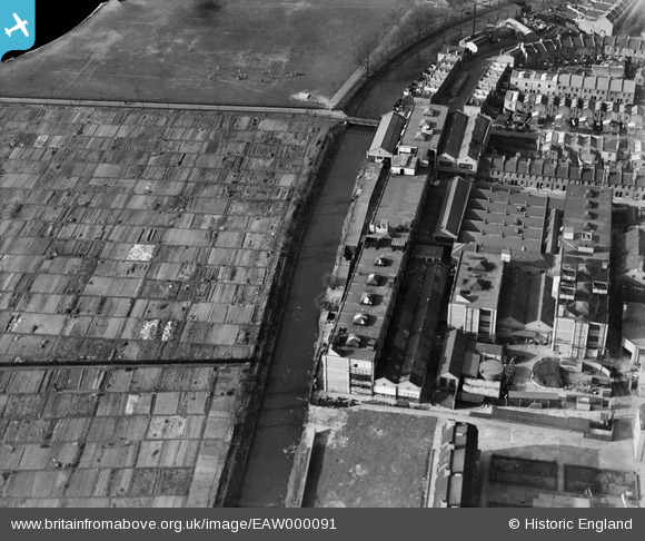
EAW000091 ENGLAND (1946). The A. H. Hunt Ltd Capacitor Works alongside the River Wandle, Earlsfield, 1946. This image has been produced from a damaged negative.
© Hawlfraint cyfranwyr OpenStreetMap a thrwyddedwyd gan yr OpenStreetMap Foundation. 2026. Trwyddedir y gartograffeg fel CC BY-SA.
Delweddau cyfagos (25)
Manylion
| Pennawd | [EAW000091] The A. H. Hunt Ltd Capacitor Works alongside the River Wandle, Earlsfield, 1946. This image has been produced from a damaged negative. |
| Cyfeirnod | EAW000091 |
| Dyddiad | 1-April-1946 |
| Dolen | |
| Enw lle | EARLSFIELD |
| Plwyf | |
| Ardal | |
| Gwlad | ENGLAND |
| Dwyreiniad / Gogleddiad | 525650, 173467 |
| Hydred / Lledred | -0.19171926773491, 51.445745103746 |
| Cyfeirnod Grid Cenedlaethol | TQ257735 |
Pinnau

Sparky |
Thursday 27th of July 2017 04:22:54 PM |


![[EAW000091] The A. H. Hunt Ltd Capacitor Works alongside the River Wandle, Earlsfield, 1946. This image has been produced from a damaged negative.](http://britainfromabove.org.uk/sites/all/libraries/aerofilms-images/public/100x100/EAW/000/EAW000091.jpg)
![[EAW000093] The A. H. Hunt Ltd Capacitor Works alongside the River Wandle, Earlsfield, 1946](http://britainfromabove.org.uk/sites/all/libraries/aerofilms-images/public/100x100/EAW/000/EAW000093.jpg)
![[EAW000092] The A. H. Hunt Ltd Capacitor Works alongside the River Wandle, Earlsfield, 1946](http://britainfromabove.org.uk/sites/all/libraries/aerofilms-images/public/100x100/EAW/000/EAW000092.jpg)
![[EPW031954] The Columbia Gramophone Works and environs, Wandsworth, 1930. This image was marked by Aerofilms Ltd for photo editing.](http://britainfromabove.org.uk/sites/all/libraries/aerofilms-images/public/100x100/EPW/031/EPW031954.jpg)
![[EAW000090] The A. H. Hunt Ltd Capacitor Works alongside the River Wandle, Earlsfield, 1946](http://britainfromabove.org.uk/sites/all/libraries/aerofilms-images/public/100x100/EAW/000/EAW000090.jpg)
![[EPW031953] The Columbia Gramophone Works and environs, Wandsworth, 1930. This image was marked by Aerofilms Ltd for photo editing.](http://britainfromabove.org.uk/sites/all/libraries/aerofilms-images/public/100x100/EPW/031/EPW031953.jpg)
![[EPW031956] The Columbia Gramophone Works and environs, Wandsworth, 1930](http://britainfromabove.org.uk/sites/all/libraries/aerofilms-images/public/100x100/EPW/031/EPW031956.jpg)
![[EPW031959] The Columbia Gramophone Works and environs, Wandsworth, 1930](http://britainfromabove.org.uk/sites/all/libraries/aerofilms-images/public/100x100/EPW/031/EPW031959.jpg)
![[EPW031957] The Columbia Gramophone Works and environs, Wandsworth, 1930](http://britainfromabove.org.uk/sites/all/libraries/aerofilms-images/public/100x100/EPW/031/EPW031957.jpg)
![[EAW000089] The A. H. Hunt Ltd Capacitor Works and the surrounding residential area, Earlsfield, 1946](http://britainfromabove.org.uk/sites/all/libraries/aerofilms-images/public/100x100/EAW/000/EAW000089.jpg)
![[EPW031958] The Columbia Gramophone Works and environs, Wandsworth, 1930. This image was marked by Aerofilms Ltd for photo editing.](http://britainfromabove.org.uk/sites/all/libraries/aerofilms-images/public/100x100/EPW/031/EPW031958.jpg)
![[EAW000094] The A. H. Hunt Ltd Capacitor Works and the surrounding residential area, Earlsfield, 1946](http://britainfromabove.org.uk/sites/all/libraries/aerofilms-images/public/100x100/EAW/000/EAW000094.jpg)
![[EPW031955] The Columbia Gramophone Works and environs, Wandsworth, 1930. This image was marked by Aerofilms Ltd for photo editing.](http://britainfromabove.org.uk/sites/all/libraries/aerofilms-images/public/100x100/EPW/031/EPW031955.jpg)
![[EPW058598] Coleman Court, Kimber Road, Burr Road and environs, Southfields, 1938](http://britainfromabove.org.uk/sites/all/libraries/aerofilms-images/public/100x100/EPW/058/EPW058598.jpg)
![[EPW060337] Coleman Court, Kimber Road, Burr Road and environs, Southfields, 1939](http://britainfromabove.org.uk/sites/all/libraries/aerofilms-images/public/100x100/EPW/060/EPW060337.jpg)
![[EPW058595] Coleman Court, Kimber Road, Burr Road and environs, Southfields, 1938](http://britainfromabove.org.uk/sites/all/libraries/aerofilms-images/public/100x100/EPW/058/EPW058595.jpg)
![[EPW058948] Coleman Court, Kimber Road, Burr Road and environs, Southfields, 1938](http://britainfromabove.org.uk/sites/all/libraries/aerofilms-images/public/100x100/EPW/058/EPW058948.jpg)
![[EPW060338] Coleman Court, Kimber Road, Burr Road and environs, Southfields, 1939](http://britainfromabove.org.uk/sites/all/libraries/aerofilms-images/public/100x100/EPW/060/EPW060338.jpg)
![[EPW060339] Coleman Court, Kimber Road, Burr Road and environs, Southfields, 1939](http://britainfromabove.org.uk/sites/all/libraries/aerofilms-images/public/100x100/EPW/060/EPW060339.jpg)
![[EPW058949] Coleman Court, Kimber Road, Burr Road and environs, Southfields, 1938](http://britainfromabove.org.uk/sites/all/libraries/aerofilms-images/public/100x100/EPW/058/EPW058949.jpg)
![[EPW058947] Coleman Court on Kimber Road, Southfields, 1938](http://britainfromabove.org.uk/sites/all/libraries/aerofilms-images/public/100x100/EPW/058/EPW058947.jpg)
![[EPW060341] Coleman Court, Kimber Road, Burr Road and environs, Southfields, 1939](http://britainfromabove.org.uk/sites/all/libraries/aerofilms-images/public/100x100/EPW/060/EPW060341.jpg)
![[EPW060340] Coleman Court, Kimber Road, Burr Road and environs, Southfields, 1939](http://britainfromabove.org.uk/sites/all/libraries/aerofilms-images/public/100x100/EPW/060/EPW060340.jpg)
![[EPW058946] Coleman Court, Kimber Road, Burr Road and environs, Southfields, 1938](http://britainfromabove.org.uk/sites/all/libraries/aerofilms-images/public/100x100/EPW/058/EPW058946.jpg)
![[EPW060336] Coleman Court, Kimber Road, Burr Road and environs, Southfields, 1939](http://britainfromabove.org.uk/sites/all/libraries/aerofilms-images/public/100x100/EPW/060/EPW060336.jpg)