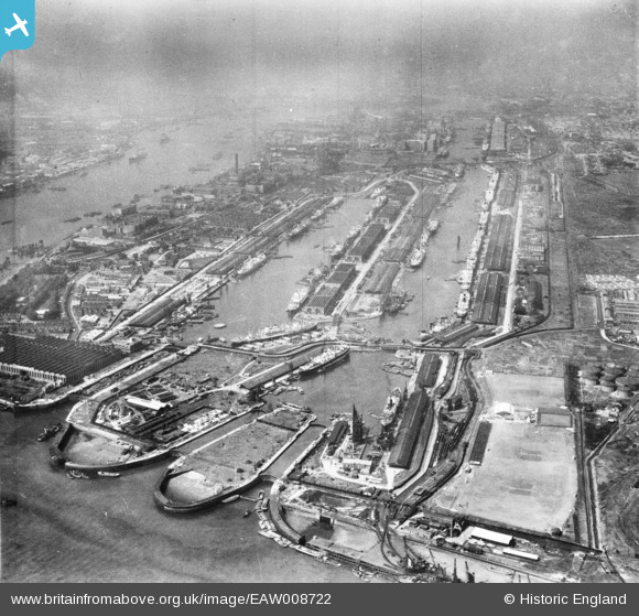
eaw008722 ENGLAND (1947). The Royal Albert Dock and the King George V Dock, North Woolwich, 1947
© Copyright OpenStreetMap contributors and licensed by the OpenStreetMap Foundation. 2026. Cartography is licensed as CC BY-SA.
Nearby Images (24)
Details
| Title | [EAW008722] The Royal Albert Dock and the King George V Dock, North Woolwich, 1947 |
| Reference | EAW008722 |
| Date | 8-August-1947 |
| Link | |
| Place name | NORTH WOOLWICH |
| Parish | |
| District | |
| Country | ENGLAND |
| Easting / Northing | 543480, 180401 |
| Longitude / Latitude | 0.067527689148312, 51.503821915652 |
| National Grid Reference | TQ435804 |
Pins

redmist |
Monday 29th of June 2020 07:46:00 PM | |

redmist |
Monday 29th of June 2020 07:37:26 PM | |

redmist |
Monday 29th of June 2020 07:36:39 PM |


![[EAW008722] The Royal Albert Dock and the King George V Dock, North Woolwich, 1947](http://britainfromabove.org.uk/sites/all/libraries/aerofilms-images/public/100x100/EAW/008/EAW008722.jpg)
![[EPW008885] King George V Dock and the Royal Albert Dock, North Woolwich, 1923](http://britainfromabove.org.uk/sites/all/libraries/aerofilms-images/public/100x100/EPW/008/EPW008885.jpg)
![[EAW005290] The Royal Albert Dock, King George V Dock and environs, North Woolwich, from the east, 1947](http://britainfromabove.org.uk/sites/all/libraries/aerofilms-images/public/100x100/EAW/005/EAW005290.jpg)
![[EAW014133] King George V Dock and Royal Albert Dock, North Woolwich, from the east, 1948. This image has been produced from a print.](http://britainfromabove.org.uk/sites/all/libraries/aerofilms-images/public/100x100/EAW/014/EAW014133.jpg)
![[EAW008723] The Royal Albert Dock and the King George V Dock, North Woolwich, 1947](http://britainfromabove.org.uk/sites/all/libraries/aerofilms-images/public/100x100/EAW/008/EAW008723.jpg)
![[EAW008724] The Royal Albert Dock and the King George V Dock, North Woolwich, 1947](http://britainfromabove.org.uk/sites/all/libraries/aerofilms-images/public/100x100/EAW/008/EAW008724.jpg)
![[EPW032935] The Royal Albert Dock and King George V Dock, North Woolwich, 1930](http://britainfromabove.org.uk/sites/all/libraries/aerofilms-images/public/100x100/EPW/032/EPW032935.jpg)
![[EPW008887] King George V Dock and the Royal Albert Dock, North Woolwich, 1923. This image has been produced from a print.](http://britainfromabove.org.uk/sites/all/libraries/aerofilms-images/public/100x100/EPW/008/EPW008887.jpg)
![[EAW000051] The King George V Dock and the Royal Albert Dock, Beckton, 1946](http://britainfromabove.org.uk/sites/all/libraries/aerofilms-images/public/100x100/EAW/000/EAW000051.jpg)
![[EAW008728] The Royal Albert Dock and the King George V Dock, North Woolwich, 1947](http://britainfromabove.org.uk/sites/all/libraries/aerofilms-images/public/100x100/EAW/008/EAW008728.jpg)
![[EAW049351] The Royal Group of Docks, North Woolwich, 1953](http://britainfromabove.org.uk/sites/all/libraries/aerofilms-images/public/100x100/EAW/049/EAW049351.jpg)
![[EAW022358] The Royal Albert and King George V Docks and environs, North Woolwich, from the east, 1949](http://britainfromabove.org.uk/sites/all/libraries/aerofilms-images/public/100x100/EAW/022/EAW022358.jpg)
![[EAW022357] The Royal Albert and King George V Docks, North Woolwich, 1949](http://britainfromabove.org.uk/sites/all/libraries/aerofilms-images/public/100x100/EAW/022/EAW022357.jpg)
![[EAW008726] The Royal Albert Dock and the King George V Dock, North Woolwich, 1947](http://britainfromabove.org.uk/sites/all/libraries/aerofilms-images/public/100x100/EAW/008/EAW008726.jpg)
![[EAW000058] The King George V Dock and the Royal Albert Dock, Beckton, 1946. This image has been produced from a damaged negative.](http://britainfromabove.org.uk/sites/all/libraries/aerofilms-images/public/100x100/EAW/000/EAW000058.jpg)
![[EAW000057] The Royal Victoria Dock, the Royal Albert Dock and the King George V Dock, North Woolwich, 1946. This image was produced from a print.](http://britainfromabove.org.uk/sites/all/libraries/aerofilms-images/public/100x100/EAW/000/EAW000057.jpg)
![[EAW000050] The King George V Dock and the Royal Albert Dock, Beckton, 1946](http://britainfromabove.org.uk/sites/all/libraries/aerofilms-images/public/100x100/EAW/000/EAW000050.jpg)
![[EAW000054] The King George V Dock and the Royal Albert Dock, Beckton, 1946](http://britainfromabove.org.uk/sites/all/libraries/aerofilms-images/public/100x100/EAW/000/EAW000054.jpg)
![[EAW005289] The Royal Albert Dock, King George V Dock and environs, North Woolwich, from the south-east, 1947](http://britainfromabove.org.uk/sites/all/libraries/aerofilms-images/public/100x100/EAW/005/EAW005289.jpg)
![[EPW032936] The Royal Albert Dock and King George V Dock, North Woolwich, 1930](http://britainfromabove.org.uk/sites/all/libraries/aerofilms-images/public/100x100/EPW/032/EPW032936.jpg)
![[EPW044121] The Royal Group of Docks, East Ham, from the east, 1934](http://britainfromabove.org.uk/sites/all/libraries/aerofilms-images/public/100x100/EPW/044/EPW044121.jpg)
![[EAW008740] The Harland and Wolff Ltd Works and the Royal Albert Dock and the King George V Dock, North Woolwich, 1947](http://britainfromabove.org.uk/sites/all/libraries/aerofilms-images/public/100x100/EAW/008/EAW008740.jpg)
![[EAW000055] The King George V Dock and the Royal Albert Dock, Beckton, 1946](http://britainfromabove.org.uk/sites/all/libraries/aerofilms-images/public/100x100/EAW/000/EAW000055.jpg)
![[EAW016657] The Royal Albert Dock, King George V Dock, River Thames and environs, North Woolwich, from the north-west, 1948](http://britainfromabove.org.uk/sites/all/libraries/aerofilms-images/public/100x100/EAW/016/EAW016657.jpg)