
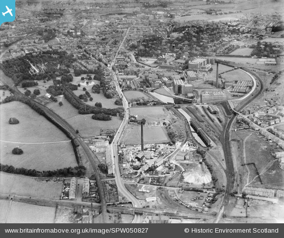
SPW050827 SCOTLAND (1936). Paisley, general view, showing Ferguslie Fireclay Works and J and P Coats Ltd. Ferguslie Mills Thread Works. An oblique aerial photograph taken facing east.
© Copyright OpenStreetMap contributors and licensed by the OpenStreetMap Foundation. 2026. Cartography is licensed as CC BY-SA.
Nearby Images (12)
SPW050827

SPW027034

SPW042503

SPW042505

SPW027028

SPW045833

SAR008797

SPW019485

SPW027035

SPW042502

SPW019484

SPW027030

Details
| Title | [SPW050827] Paisley, general view, showing Ferguslie Fireclay Works and J and P Coats Ltd. Ferguslie Mills Thread Works. An oblique aerial photograph taken facing east. |
| Reference | SPW050827 |
| Date | 1936 |
| Link | NRHE Collection item 1257846 |
| Place name | |
| Parish | PAISLEY (RENFREW) |
| District | RENFREW |
| Country | SCOTLAND |
| Easting / Northing | 246490, 663380 |
| Longitude / Latitude | -4.4517118327644, 55.839204616546 |
| National Grid Reference | NS465634 |
Pins

jimmy |
Tuesday 30th of January 2018 02:08:31 PM | |
|
jaypea |
Monday 18th of January 2016 02:33:47 PM | |
|
jaypea |
Saturday 16th of January 2016 09:23:59 PM | |
|
Ewen |
Wednesday 9th of December 2015 11:40:50 PM | |
|
Ewen |
Wednesday 9th of December 2015 11:36:13 PM | |
 |
Ewen |
Wednesday 9th of December 2015 11:32:42 PM |
|
Ewen |
Wednesday 9th of December 2015 11:20:28 PM | |
|
Ewen |
Wednesday 9th of December 2015 11:18:35 PM | |
|
Ewen |
Wednesday 9th of December 2015 11:16:57 PM | |
|
Ewen |
Wednesday 9th of December 2015 11:11:59 PM | |
|
Ewen |
Wednesday 9th of December 2015 11:08:48 PM | |
|
Ewen |
Wednesday 9th of December 2015 11:06:47 PM | |
|
bossjock |
Friday 25th of October 2013 11:18:35 PM | |
|
bossjock |
Sunday 28th of April 2013 08:23:30 PM | |
|
Brian |
Wednesday 17th of April 2013 05:35:11 PM | |
|
Brian |
Wednesday 17th of April 2013 05:34:37 PM | |
|
Brian |
Wednesday 17th of April 2013 05:32:52 PM | |
|
jimmy |
Wednesday 13th of February 2013 02:08:30 PM | |
|
jimmy |
Wednesday 13th of February 2013 02:07:35 PM | |
|
jimmy |
Saturday 9th of February 2013 09:30:44 PM | |
|
gordon |
Tuesday 11th of December 2012 06:39:05 PM | |
|
bossjock |
Friday 19th of October 2012 06:21:00 PM | |
|
bossjock |
Friday 19th of October 2012 06:20:05 PM | |
|
jimmy |
Wednesday 29th of August 2012 12:39:11 PM | |
|
Mitch70 |
Friday 27th of July 2012 10:35:59 PM | |
|
Mitch70 |
Thursday 26th of July 2012 04:06:25 AM | |
This was a coal merchants, Hargreaves I think. |
Danny55 |
Thursday 9th of October 2014 06:44:55 AM |
|
Mitch70 |
Thursday 26th of July 2012 04:05:24 AM | |
|
Mitch70 |
Thursday 26th of July 2012 04:05:23 AM | |
|
Mitch70 |
Thursday 26th of July 2012 04:03:00 AM | |
|
Mitch70 |
Thursday 26th of July 2012 04:00:05 AM |