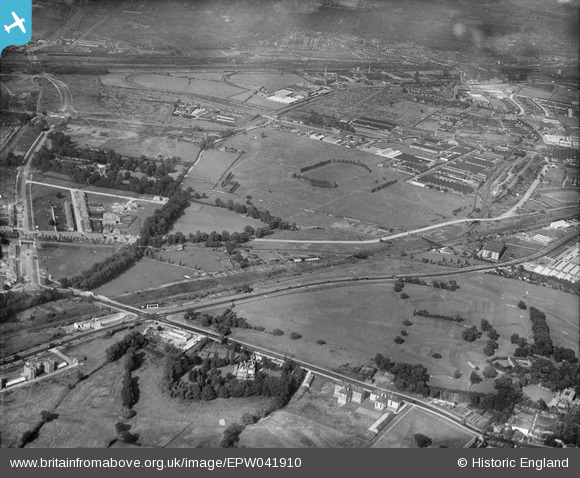
EPW041910 ENGLAND (1933). The Horse Ring football ground and various factories, Park Royal, from the south-west, 1933
© Copyright OpenStreetMap contributors and licensed by the OpenStreetMap Foundation. 2026. Cartography is licensed as CC BY-SA.
Nearby Images (17)
Details
| Title | [EPW041910] The Horse Ring football ground and various factories, Park Royal, from the south-west, 1933 |
| Reference | EPW041910 |
| Date | June-1933 |
| Link | |
| Place name | PARK ROYAL |
| Parish | |
| District | |
| Country | ENGLAND |
| Easting / Northing | 519076, 182533 |
| Longitude / Latitude | -0.28322311119232, 51.528655480994 |
| National Grid Reference | TQ191825 |
Pins

Leslie B |
Thursday 29th of February 2024 07:26:23 PM | |

Leslie B |
Tuesday 2nd of January 2024 04:18:44 PM | |

Leslie B |
Tuesday 2nd of January 2024 04:12:40 PM | |

Mikkel |
Wednesday 22nd of February 2017 07:54:58 AM | |

Leslie B |
Tuesday 23rd of February 2016 12:45:01 AM | |

Class31 |
Wednesday 19th of August 2015 11:31:18 AM | |

Class31 |
Wednesday 19th of August 2015 09:06:15 AM | |

Class31 |
Wednesday 19th of August 2015 09:04:31 AM | |

Class31 |
Wednesday 19th of August 2015 09:03:47 AM |


![[EPW041910] The Horse Ring football ground and various factories, Park Royal, from the south-west, 1933](http://britainfromabove.org.uk/sites/all/libraries/aerofilms-images/public/100x100/EPW/041/EPW041910.jpg)
![[EPW041848] The Horse Ring football ground, Park Royal, from the south-west, 1933. This image has been produced from a damaged negative.](http://britainfromabove.org.uk/sites/all/libraries/aerofilms-images/public/100x100/EPW/041/EPW041848.jpg)
![[EPW041913] The Horse Ring football ground and various factories, Park Royal, from the south-west, 1933](http://britainfromabove.org.uk/sites/all/libraries/aerofilms-images/public/100x100/EPW/041/EPW041913.jpg)
![[EPW041912] The Horse Ring football ground and various factories, Park Royal, from the south-west, 1933](http://britainfromabove.org.uk/sites/all/libraries/aerofilms-images/public/100x100/EPW/041/EPW041912.jpg)
![[EPR000520] The Guinness Brewery under construction, Park Royal, from the south-west, 1935](http://britainfromabove.org.uk/sites/all/libraries/aerofilms-images/public/100x100/EPR/000/EPR000520.jpg)
![[EAW031543] The Guinness Brewery and environs, Park Royal, 1950. This image has been produced from a print marked by Aerofilms Ltd for photo editing.](http://britainfromabove.org.uk/sites/all/libraries/aerofilms-images/public/100x100/EAW/031/EAW031543.jpg)
![[EAW031548] The Guinness Brewery, Park Royal, 1950. This image has been produced from a print.](http://britainfromabove.org.uk/sites/all/libraries/aerofilms-images/public/100x100/EAW/031/EAW031548.jpg)
![[EAW031545] The Guinness Brewery and environs, Park Royal, 1950. This image has been produced from a print marked by Aerofilms Ltd for photo editing.](http://britainfromabove.org.uk/sites/all/libraries/aerofilms-images/public/100x100/EAW/031/EAW031545.jpg)
![[EAW031553] The Guinness Brewery and environs, Park Royal, 1950. This image has been produced from a print marked by Aerofilms Ltd for photo editing.](http://britainfromabove.org.uk/sites/all/libraries/aerofilms-images/public/100x100/EAW/031/EAW031553.jpg)
![[EPR000519] The Guinness Brewery under construction, Park Royal, 1935. This image has been produced from a damaged negative.](http://britainfromabove.org.uk/sites/all/libraries/aerofilms-images/public/100x100/EPR/000/EPR000519.jpg)
![[EPW041911] The Horse Ring football ground and various factories, Park Royal, from the south-west, 1933](http://britainfromabove.org.uk/sites/all/libraries/aerofilms-images/public/100x100/EPW/041/EPW041911.jpg)
![[EAW031550] The Guinness Brewery and environs, Park Royal, 1950. This image has been produced from a print marked by Aerofilms Ltd for photo editing.](http://britainfromabove.org.uk/sites/all/libraries/aerofilms-images/public/100x100/EAW/031/EAW031550.jpg)
![[EAW031542] The Guinness Brewery, Park Royal, 1950. This image has been produced from a print.](http://britainfromabove.org.uk/sites/all/libraries/aerofilms-images/public/100x100/EAW/031/EAW031542.jpg)
![[EAW031546] The Guinness Brewery, Park Royal, 1950. This image has been produced from a print.](http://britainfromabove.org.uk/sites/all/libraries/aerofilms-images/public/100x100/EAW/031/EAW031546.jpg)
![[EPW055718] The Guinness Brewery, Park Royal, 1937. This image has been produced from a copy-negative.](http://britainfromabove.org.uk/sites/all/libraries/aerofilms-images/public/100x100/EPW/055/EPW055718.jpg)
![[EPW041914] The Horse Ring football ground and various factories, Park Royal, from the south-west, 1933](http://britainfromabove.org.uk/sites/all/libraries/aerofilms-images/public/100x100/EPW/041/EPW041914.jpg)
![[EAW031544] The Guinness Brewery, Park Royal, 1950. This image has been produced from a print.](http://britainfromabove.org.uk/sites/all/libraries/aerofilms-images/public/100x100/EAW/031/EAW031544.jpg)
