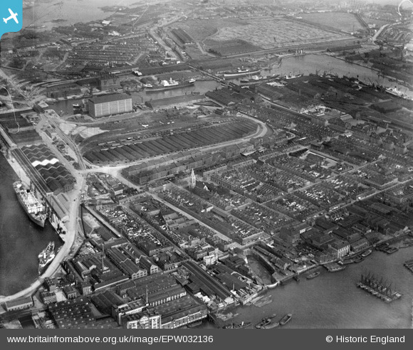
EPW032136 ENGLAND (1930). The Western Granaries and Grain Depot at Millwall Inner Dock, Millwall, 1930
© Copyright OpenStreetMap contributors and licensed by the OpenStreetMap Foundation. 2026. Cartography is licensed as CC BY-SA.
Nearby Images (12)
Details
| Title | [EPW032136] The Western Granaries and Grain Depot at Millwall Inner Dock, Millwall, 1930 |
| Reference | EPW032136 |
| Date | May-1930 |
| Link | |
| Place name | MILLWALL |
| Parish | |
| District | |
| Country | ENGLAND |
| Easting / Northing | 537370, 179676 |
| Longitude / Latitude | -0.020741204449109, 51.498824663662 |
| National Grid Reference | TQ374797 |
Pins

FREDSDAD |
Thursday 5th of May 2022 09:41:11 PM | |

moses72 |
Thursday 1st of October 2015 11:13:03 AM | |

moses72 |
Friday 21st of June 2013 01:45:41 PM | |

moses72 |
Friday 21st of June 2013 01:44:52 PM | |

moses72 |
Friday 21st of June 2013 01:43:03 PM | |

moses72 |
Friday 21st of June 2013 01:40:27 PM | |

moses72 |
Friday 21st of June 2013 01:39:37 PM | |

moses72 |
Friday 21st of June 2013 01:38:57 PM | |

moses72 |
Friday 21st of June 2013 01:38:08 PM | |

moses72 |
Friday 21st of June 2013 01:35:23 PM | |

PeterJames |
Monday 31st of December 2012 06:53:07 PM |


![[EPW032136] The Western Granaries and Grain Depot at Millwall Inner Dock, Millwall, 1930](http://britainfromabove.org.uk/sites/all/libraries/aerofilms-images/public/100x100/EPW/032/EPW032136.jpg)
![[EPW032140] The Western Granaries and Grain Depot, Millwall, 1930](http://britainfromabove.org.uk/sites/all/libraries/aerofilms-images/public/100x100/EPW/032/EPW032140.jpg)
![[EPW032143] The Western Granaries and Grain Depot, Millwall, 1930](http://britainfromabove.org.uk/sites/all/libraries/aerofilms-images/public/100x100/EPW/032/EPW032143.jpg)
![[EPW032141] The Western Granaries and Grain Depot, Millwall, 1930](http://britainfromabove.org.uk/sites/all/libraries/aerofilms-images/public/100x100/EPW/032/EPW032141.jpg)
![[EPW032138] Western Granaries, Grain Depot and South Dock, Millwall, 1930](http://britainfromabove.org.uk/sites/all/libraries/aerofilms-images/public/100x100/EPW/032/EPW032138.jpg)
![[EPW032137] Aplha Road and environs, Millwall, 1930](http://britainfromabove.org.uk/sites/all/libraries/aerofilms-images/public/100x100/EPW/032/EPW032137.jpg)
![[EPW032139] Western Granaries, the Grain Depot and Millwall Inner Dock, Millwall, 1930](http://britainfromabove.org.uk/sites/all/libraries/aerofilms-images/public/100x100/EPW/032/EPW032139.jpg)
![[EPW032142] The Western Granaries and Grain Depot, Millwall, 1930](http://britainfromabove.org.uk/sites/all/libraries/aerofilms-images/public/100x100/EPW/032/EPW032142.jpg)
![[EPW044135] South Dock, Millwall Inner Dock and environs, Isle of Dogs, 1934](http://britainfromabove.org.uk/sites/all/libraries/aerofilms-images/public/100x100/EPW/044/EPW044135.jpg)
![[EAW009114] Millwall, Isle of Dogs, 1947](http://britainfromabove.org.uk/sites/all/libraries/aerofilms-images/public/100x100/EAW/009/EAW009114.jpg)
![[EPW044128] West India and Millwall Docks, Isle of Dogs, from the south-west, 1934](http://britainfromabove.org.uk/sites/all/libraries/aerofilms-images/public/100x100/EPW/044/EPW044128.jpg)
![[EAW045808] Strafford Street and wharfage on the River Thames behind West Ferry Road, Millwall, 1952. This image was marked by Aerofilms Ltd for photo editing.](http://britainfromabove.org.uk/sites/all/libraries/aerofilms-images/public/100x100/EAW/045/EAW045808.jpg)