
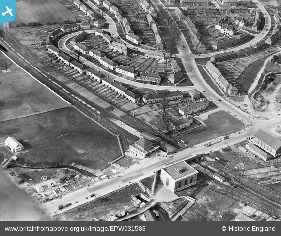
EPW031583 ENGLAND (1930). Burnt Oak Railway Station and Blessbury Road, Burnt Oak, 1930
© Copyright OpenStreetMap contributors and licensed by the OpenStreetMap Foundation. 2026. Cartography is licensed as CC BY-SA.
Nearby Images (23)
EPW031583

EPW031548

EPW031549

EPW009363

EPW009347

EPW009345

EPW016519

EPW016517

EPW009344

EPW009682

EPW009346

EPW034858

EPW019192

EPW035548

EPW031550

EPW009355

EPW019336

EPW001350

EPW016518

EPW019190

EPW035547

EPW019191

EPW019193

Details
| Title | [EPW031583] Burnt Oak Railway Station and Blessbury Road, Burnt Oak, 1930 |
| Reference | EPW031583 |
| Date | February-1930 |
| Link | |
| Place name | BURNT OAK |
| Parish | |
| District | |
| Country | ENGLAND |
| Easting / Northing | 520295, 190813 |
| Longitude / Latitude | -0.26282217337715, 51.602819977544 |
| National Grid Reference | TQ203908 |
Pins

Airwick |
Sunday 12th of March 2023 08:12:25 PM | |
|
AndrewGVT |
Saturday 22nd of March 2014 10:48:57 AM | |
|
bazouteast |
Tuesday 18th of March 2014 09:33:40 PM | |
|
colsouth111 |
Wednesday 7th of August 2013 11:54:31 AM | |
|
colsouth111 |
Wednesday 7th of August 2013 11:46:07 AM |
User Comment Contributions

Burnt Oak station now properly built at street level, some six years after the station opened! No shops yet on the opposite side of the Watling, where I seem to remember Toni's Ice Cream Parlour. |
colsouth111 |
Wednesday 7th of August 2013 11:56:48 AM |