
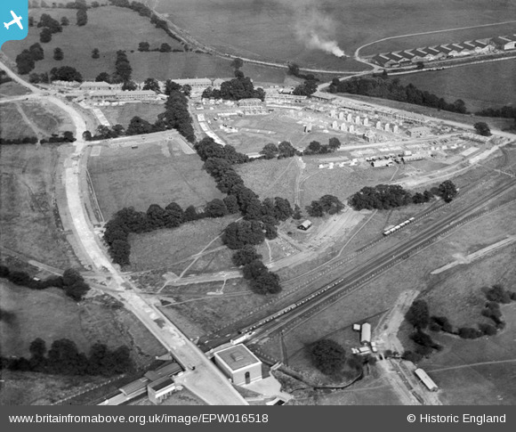
EPW016518 ENGLAND (1926). Housing under construction in the Gloucester Grove area, Burnt Oak, 1926
© Copyright OpenStreetMap contributors and licensed by the OpenStreetMap Foundation. 2026. Cartography is licensed as CC BY-SA.
Nearby Images (21)
EPW016518

EPW031550

EPW019336

EPW035548

EPW034858

EPW016517

EPW009682

EPW019335

EPW009344

EPW016519

EPW009363

EPW009346

EPW031549

EPW031548

EPW009345

EPW009347

EPW019338

EPW017586

EPW031583

EPW019337

EPW019192

Details
| Title | [EPW016518] Housing under construction in the Gloucester Grove area, Burnt Oak, 1926 |
| Reference | EPW016518 |
| Date | August-1926 |
| Link | |
| Place name | BURNT OAK |
| Parish | |
| District | |
| Country | ENGLAND |
| Easting / Northing | 520501, 190708 |
| Longitude / Latitude | -0.25988489171471, 51.601832168267 |
| National Grid Reference | TQ205907 |
Pins
Be the first to add a comment to this image!
User Comment Contributions

Work begins on the Watling estate. |

colsouth111 |
Wednesday 7th of August 2013 01:25:08 PM |