
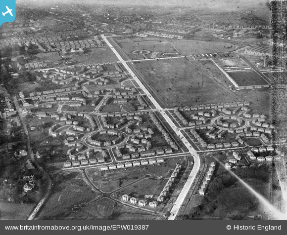
EPW019387 ENGLAND (1927). Western Circle and the Kingsway Estate, Burnage, 1927
© Copyright OpenStreetMap contributors and licensed by the OpenStreetMap Foundation. 2026. Cartography is licensed as CC BY-SA.
Nearby Images (15)
EPW019387

EPW019124

EPW019390

EPW019126

EPW019394

EPW019388

EPW019128

EPW019123

EPW019125

EPW019386

EPW019392

EPW019122

EPW019127

EPW019393

EPW019389

Details
| Title | [EPW019387] Western Circle and the Kingsway Estate, Burnage, 1927 |
| Reference | EPW019387 |
| Date | 30-September-1927 |
| Link | |
| Place name | BURNAGE |
| Parish | |
| District | |
| Country | ENGLAND |
| Easting / Northing | 387050, 392775 |
| Longitude / Latitude | -2.19493270291, 53.431343670594 |
| National Grid Reference | SJ871928 |
Pins

DreamReiver |
Saturday 3rd of September 2016 03:58:30 PM | |
|
John Ellis |
Sunday 9th of September 2012 05:50:36 PM | |
|
John Ellis |
Tuesday 4th of September 2012 09:28:46 PM | |
|
John Ellis |
Tuesday 4th of September 2012 09:27:51 PM | |
|
John Ellis |
Tuesday 4th of September 2012 09:26:30 PM | |
|
John Ellis |
Tuesday 4th of September 2012 09:25:44 PM | |
|
John Ellis |
Tuesday 4th of September 2012 09:24:59 PM | |
|
John Ellis |
Tuesday 4th of September 2012 09:23:47 PM | |
|
John Ellis |
Tuesday 4th of September 2012 09:23:06 PM | |
|
John Ellis |
Tuesday 4th of September 2012 09:22:42 PM | |
|
John Ellis |
Tuesday 4th of September 2012 09:21:22 PM | |
|
John Ellis |
Tuesday 4th of September 2012 09:20:14 PM | |
|
John Ellis |
Tuesday 4th of September 2012 09:19:50 PM | |
|
John Ellis |
Tuesday 4th of September 2012 09:18:57 PM | |
|
John Ellis |
Tuesday 4th of September 2012 09:18:30 PM | |
|
John Ellis |
Tuesday 4th of September 2012 09:17:53 PM | |
Strictly speaking the park north of Crossley Road is Cringle Park (used to be Errwood Park) and the playing fields south of it are Cringle Fields. |
Oskareel |
Thursday 5th of February 2015 07:16:45 PM |
|
John Ellis |
Tuesday 4th of September 2012 09:17:07 PM |
User Comment Contributions
Ashburn Avenue unbuilt to the left at the bottom (road laid out) |
Crofter56 |
Tuesday 26th of June 2012 10:53:45 AM |