
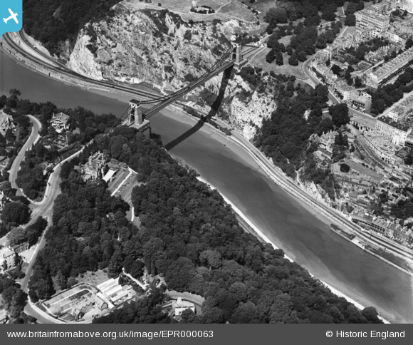
EPR000063 ENGLAND (1934). The Clifton Suspension Bridge, Clifton, 1934
© Copyright OpenStreetMap contributors and licensed by the OpenStreetMap Foundation. 2026. Cartography is licensed as CC BY-SA.
Nearby Images (18)
EPR000063

EAW050558

EAW016132

EPW022272

EAW050559

EAW050560

EAW002263

EPW032539

EPW022273

EAW033325

EPW001274

EPW037150

EPW041480

EAW015138

EAW033323

EAW033327

EPW012024

EPW032526

Details
| Title | [EPR000063] The Clifton Suspension Bridge, Clifton, 1934 |
| Reference | EPR000063 |
| Date | 4-July-1934 |
| Link | |
| Place name | CLIFTON |
| Parish | |
| District | |
| Country | ENGLAND |
| Easting / Northing | 356487, 173020 |
| Longitude / Latitude | -2.6263060268503, 51.453998479146 |
| National Grid Reference | ST565730 |
Pins

RFD W'ton |
Thursday 16th of August 2018 11:36:49 PM | |
|
RFD W'ton |
Thursday 16th of August 2018 11:34:36 PM |