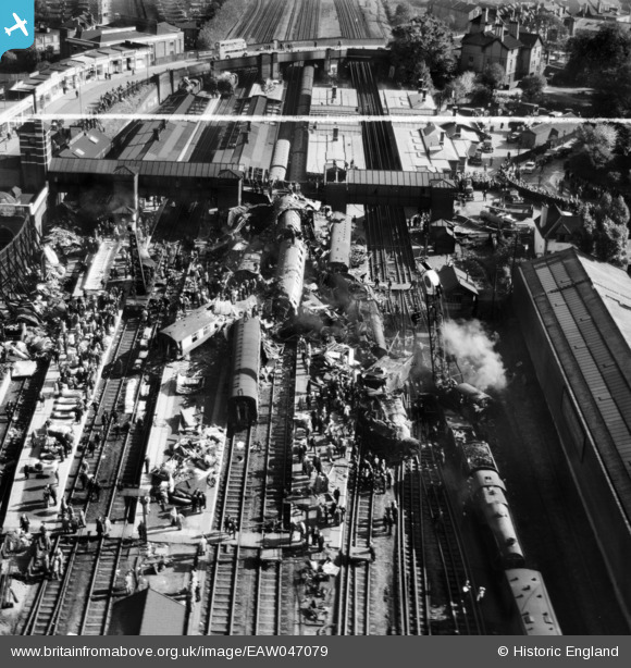
EAW047079 ENGLAND (1952). The aftermath of the Harrow and Wealdstone rail crash, Wealdstone, 1952. This image was marked by Aerofilms Ltd for photo editing.
© Copyright OpenStreetMap contributors and licensed by the OpenStreetMap Foundation. 2026. Cartography is licensed as CC BY-SA.
Nearby Images (23)
Details
| Title | [EAW047079] The aftermath of the Harrow and Wealdstone rail crash, Wealdstone, 1952. This image was marked by Aerofilms Ltd for photo editing. |
| Reference | EAW047079 |
| Date | 8-October-1952 |
| Link | |
| Place name | WEALDSTONE |
| Parish | |
| District | |
| Country | ENGLAND |
| Easting / Northing | 515423, 189475 |
| Longitude / Latitude | -0.33358623021972, 51.59181312017 |
| National Grid Reference | TQ154895 |
Pins
Be the first to add a comment to this image!


![[EAW047079] The aftermath of the Harrow and Wealdstone rail crash, Wealdstone, 1952. This image was marked by Aerofilms Ltd for photo editing.](http://britainfromabove.org.uk/sites/all/libraries/aerofilms-images/public/100x100/EAW/047/EAW047079.jpg)
![[EAW047076] The aftermath of the Harrow and Wealdstone rail crash, Wealdstone, 1952. This image was marked by Aerofilms Ltd for photo editing.](http://britainfromabove.org.uk/sites/all/libraries/aerofilms-images/public/100x100/EAW/047/EAW047076.jpg)
![[EAW047078] The aftermath of the Harrow and Wealdstone rail crash, Wealdstone, 1952. This image was marked by Aerofilms Ltd for photo editing.](http://britainfromabove.org.uk/sites/all/libraries/aerofilms-images/public/100x100/EAW/047/EAW047078.jpg)
![[EAW047077] The aftermath of the Harrow and Wealdstone rail crash, Wealdstone, 1952. This image was marked by Aerofilms Ltd for photo editing.](http://britainfromabove.org.uk/sites/all/libraries/aerofilms-images/public/100x100/EAW/047/EAW047077.jpg)
![[EAW047073] The aftermath of the Harrow and Wealdstone rail crash, Wealdstone, 1952. This image was marked by Aerofilms Ltd for photo editing.](http://britainfromabove.org.uk/sites/all/libraries/aerofilms-images/public/100x100/EAW/047/EAW047073.jpg)
![[EAW047080] The aftermath of the Harrow and Wealdstone rail crash, Wealdstone, 1952. This image was marked by Aerofilms Ltd for photo editing.](http://britainfromabove.org.uk/sites/all/libraries/aerofilms-images/public/100x100/EAW/047/EAW047080.jpg)
![[EAW047072] The aftermath of the Harrow and Wealdstone rail crash, Wealdstone, 1952. This image was marked by Aerofilms Ltd for photo editing.](http://britainfromabove.org.uk/sites/all/libraries/aerofilms-images/public/100x100/EAW/047/EAW047072.jpg)
![[EAW047085] The aftermath of the Harrow and Wealdstone rail crash, Wealdstone, 1952. This image was marked by Aerofilms Ltd for photo editing.](http://britainfromabove.org.uk/sites/all/libraries/aerofilms-images/public/100x100/EAW/047/EAW047085.jpg)
![[EAW047075] The aftermath of the Harrow and Wealdstone rail crash, Wealdstone, 1952. This image was marked by Aerofilms Ltd for photo editing.](http://britainfromabove.org.uk/sites/all/libraries/aerofilms-images/public/100x100/EAW/047/EAW047075.jpg)
![[EAW047082] The aftermath of the Harrow and Wealdstone rail crash, Wealdstone, 1952. This image was marked by Aerofilms Ltd for photo editing.](http://britainfromabove.org.uk/sites/all/libraries/aerofilms-images/public/100x100/EAW/047/EAW047082.jpg)
![[EAW047084] The aftermath of the Harrow and Wealdstone rail crash, Wealdstone, 1952. This image was marked by Aerofilms Ltd for photo editing.](http://britainfromabove.org.uk/sites/all/libraries/aerofilms-images/public/100x100/EAW/047/EAW047084.jpg)
![[EAW047083] The aftermath of the Harrow and Wealdstone rail crash, Wealdstone, 1952. This image was marked by Aerofilms Ltd for photo editing.](http://britainfromabove.org.uk/sites/all/libraries/aerofilms-images/public/100x100/EAW/047/EAW047083.jpg)
![[EAW047069] The aftermath of the Harrow and Wealdstone rail crash, Wealdstone, 1952. This image was marked by Aerofilms Ltd for photo editing.](http://britainfromabove.org.uk/sites/all/libraries/aerofilms-images/public/100x100/EAW/047/EAW047069.jpg)
![[EAW047067] The aftermath of the Harrow and Wealdstone rail crash, Wealdstone, 1952. This image was marked by Aerofilms Ltd for photo editing.](http://britainfromabove.org.uk/sites/all/libraries/aerofilms-images/public/100x100/EAW/047/EAW047067.jpg)
![[EAW047066] The aftermath of the Harrow and Wealdstone rail crash, Wealdstone, 1952. This image was marked by Aerofilms Ltd for photo editing.](http://britainfromabove.org.uk/sites/all/libraries/aerofilms-images/public/100x100/EAW/047/EAW047066.jpg)
![[EAW047065] The aftermath of the Harrow and Wealdstone rail crash, Wealdstone, 1952. This image was marked by Aerofilms Ltd for photo editing.](http://britainfromabove.org.uk/sites/all/libraries/aerofilms-images/public/100x100/EAW/047/EAW047065.jpg)
![[EAW047081] The aftermath of the Harrow and Wealdstone rail crash, Wealdstone, 1952. This image was marked by Aerofilms Ltd for photo editing.](http://britainfromabove.org.uk/sites/all/libraries/aerofilms-images/public/100x100/EAW/047/EAW047081.jpg)
![[EAW047074] The aftermath of the Harrow and Wealdstone rail crash, Wealdstone, 1952. This image was marked by Aerofilms Ltd for photo editing.](http://britainfromabove.org.uk/sites/all/libraries/aerofilms-images/public/100x100/EAW/047/EAW047074.jpg)
![[EPW053686] Harrow and Wealdstone Railway Station, Wealdstone, 1937](http://britainfromabove.org.uk/sites/all/libraries/aerofilms-images/public/100x100/EPW/053/EPW053686.jpg)
![[EAW047068] The aftermath of the Harrow and Wealdstone rail crash, Wealdstone, 1952. This image was marked by Aerofilms Ltd for photo editing.](http://britainfromabove.org.uk/sites/all/libraries/aerofilms-images/public/100x100/EAW/047/EAW047068.jpg)
![[EAW047070] The aftermath of the Harrow and Wealdstone rail crash, Wealdstone, 1952. This image was marked by Aerofilms Ltd for photo editing.](http://britainfromabove.org.uk/sites/all/libraries/aerofilms-images/public/100x100/EAW/047/EAW047070.jpg)
![[EPW005359] High Street and Harrow and Wealdstone Station, Harrow, 1921](http://britainfromabove.org.uk/sites/all/libraries/aerofilms-images/public/100x100/EPW/005/EPW005359.jpg)
![[EAW047071] The aftermath of the Harrow and Wealdstone rail crash, Wealdstone, 1952. This image was marked by Aerofilms Ltd for photo editing.](http://britainfromabove.org.uk/sites/all/libraries/aerofilms-images/public/100x100/EAW/047/EAW047071.jpg)