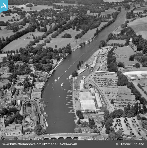
EAW044540 ENGLAND (1952). Remenham, the Henley Royal Regatta course from Phyllis Court to Temple Island, 1952
© Copyright OpenStreetMap contributors and licensed by the OpenStreetMap Foundation. 2026. Cartography is licensed as CC BY-SA.
Nearby Images (39)
Details
| Title | [EAW044540] Remenham, the Henley Royal Regatta course from Phyllis Court to Temple Island, 1952 |
| Reference | EAW044540 |
| Date | 4-July-1952 |
| Link | |
| Place name | REMENHAM |
| Parish | REMENHAM |
| District | |
| Country | ENGLAND |
| Easting / Northing | 476419, 183001 |
| Longitude / Latitude | -0.89797177522482, 51.54025012769 |
| National Grid Reference | SU764830 |
Pins
Be the first to add a comment to this image!


![[EAW044540] Remenham, the Henley Royal Regatta course from Phyllis Court to Temple Island, 1952](http://britainfromabove.org.uk/sites/all/libraries/aerofilms-images/public/100x100/EAW/044/EAW044540.jpg)
![[EAW024271] Remenham, The Royal Regatta, 1949](http://britainfromabove.org.uk/sites/all/libraries/aerofilms-images/public/100x100/EAW/024/EAW024271.jpg)
![[EAW044516] Remenham, The Henley Royal Regatta, 1952](http://britainfromabove.org.uk/sites/all/libraries/aerofilms-images/public/100x100/EAW/044/EAW044516.jpg)
![[EAW044538] Remenham, the Henley Royal Regatta course from Phyllis Court to Temple Island, 1952](http://britainfromabove.org.uk/sites/all/libraries/aerofilms-images/public/100x100/EAW/044/EAW044538.jpg)
![[EAW044551] Remenham, the Henley Royal Regatta in progress, 1952](http://britainfromabove.org.uk/sites/all/libraries/aerofilms-images/public/100x100/EAW/044/EAW044551.jpg)
![[EAW044547] Remenham, the Henley Royal Regatta in progress and the town, 1952](http://britainfromabove.org.uk/sites/all/libraries/aerofilms-images/public/100x100/EAW/044/EAW044547.jpg)
![[EPW008858] Henley-on-Thames, the approach to the finish at the Royal Regatta, 1923](http://britainfromabove.org.uk/sites/all/libraries/aerofilms-images/public/100x100/EPW/008/EPW008858.jpg)
![[EPW008857] Henley-on-Thames, the approach to the finish at the Royal Regatta, 1923](http://britainfromabove.org.uk/sites/all/libraries/aerofilms-images/public/100x100/EPW/008/EPW008857.jpg)
![[EPW008865] Henley-on-Thames, the approach to the finish at the Royal Regatta, 1923](http://britainfromabove.org.uk/sites/all/libraries/aerofilms-images/public/100x100/EPW/008/EPW008865.jpg)
![[EPW008853] Henley-on-Thames, the approach to the finish at the Royal Regatta, 1923](http://britainfromabove.org.uk/sites/all/libraries/aerofilms-images/public/100x100/EPW/008/EPW008853.jpg)
![[EAW044552] Remenham, the Henley Royal Regatta in progress, 1952](http://britainfromabove.org.uk/sites/all/libraries/aerofilms-images/public/100x100/EAW/044/EAW044552.jpg)
![[EAW044553] Remenham, the Henley Royal Regatta in progress, 1952](http://britainfromabove.org.uk/sites/all/libraries/aerofilms-images/public/100x100/EAW/044/EAW044553.jpg)
![[EPW008860] Henley-on-Thames, an Eights race approaches the finish at the Royal Regatta, 1923](http://britainfromabove.org.uk/sites/all/libraries/aerofilms-images/public/100x100/EPW/008/EPW008860.jpg)
![[EAW044537] Remenham, the Henley Royal Regatta in progress opposite Phyllis Court, 1952](http://britainfromabove.org.uk/sites/all/libraries/aerofilms-images/public/100x100/EAW/044/EAW044537.jpg)
![[EPW008856] Henley-on-Thames, an Eights race approaches the finish at the Royal Regatta, 1923](http://britainfromabove.org.uk/sites/all/libraries/aerofilms-images/public/100x100/EPW/008/EPW008856.jpg)
![[EAW024272] Remenham, The Royal Regatta, 1949](http://britainfromabove.org.uk/sites/all/libraries/aerofilms-images/public/100x100/EAW/024/EAW024272.jpg)
![[EPW008863] Henley-on-Thames, the approach to the finish at the Royal Regatta, 1923](http://britainfromabove.org.uk/sites/all/libraries/aerofilms-images/public/100x100/EPW/008/EPW008863.jpg)
![[EAW044541] Remenham, the Henley Royal Regatta course from Phyllis Court to Temple Island, 1952](http://britainfromabove.org.uk/sites/all/libraries/aerofilms-images/public/100x100/EAW/044/EAW044541.jpg)
![[EAW024270] Remenham, The Royal Regatta, 1949](http://britainfromabove.org.uk/sites/all/libraries/aerofilms-images/public/100x100/EAW/024/EAW024270.jpg)
![[EPW008861] Henley-on-Thames, an Eights race at the finish at the Royal Regatta, 1923](http://britainfromabove.org.uk/sites/all/libraries/aerofilms-images/public/100x100/EPW/008/EPW008861.jpg)
![[EAW044546] Remenham, the Henley Royal Regatta in progress and the town, 1952](http://britainfromabove.org.uk/sites/all/libraries/aerofilms-images/public/100x100/EAW/044/EAW044546.jpg)
![[EAW044549] Remenham, the Henley Royal Regatta in progress, 1952](http://britainfromabove.org.uk/sites/all/libraries/aerofilms-images/public/100x100/EAW/044/EAW044549.jpg)
![[EAW044536] Henley-on-Thames, the Henley Royal Regatta in progress opposite Phyllis Court, 1952](http://britainfromabove.org.uk/sites/all/libraries/aerofilms-images/public/100x100/EAW/044/EAW044536.jpg)
![[EAW044543] Henley-on-Thames, the Henley Royal Regatta in progress and the town, 1952](http://britainfromabove.org.uk/sites/all/libraries/aerofilms-images/public/100x100/EAW/044/EAW044543.jpg)
![[EAW044548] Remenham, the Henley Royal Regatta in progress and the town, 1952](http://britainfromabove.org.uk/sites/all/libraries/aerofilms-images/public/100x100/EAW/044/EAW044548.jpg)
![[EAW044545] Henley-on-Thames, the Henley Royal Regatta in progress and the town, 1952](http://britainfromabove.org.uk/sites/all/libraries/aerofilms-images/public/100x100/EAW/044/EAW044545.jpg)
![[EAW024274] Remenham, The Royal Regatta, 1949](http://britainfromabove.org.uk/sites/all/libraries/aerofilms-images/public/100x100/EAW/024/EAW024274.jpg)
![[EAW024273] Remenham, The Royal Regatta, 1949](http://britainfromabove.org.uk/sites/all/libraries/aerofilms-images/public/100x100/EAW/024/EAW024273.jpg)
![[EPW035810] Henley-on-Thames, The Henley Royal Regatta, 1931](http://britainfromabove.org.uk/sites/all/libraries/aerofilms-images/public/100x100/EPW/035/EPW035810.jpg)
![[EAW044550] Remenham, the Henley Royal Regatta in progress, 1952](http://britainfromabove.org.uk/sites/all/libraries/aerofilms-images/public/100x100/EAW/044/EAW044550.jpg)
![[EAW044542] Remenham, the Henley Royal Regatta in progress, 1952](http://britainfromabove.org.uk/sites/all/libraries/aerofilms-images/public/100x100/EAW/044/EAW044542.jpg)
![[EAW045423] Fawley Court and the town, Henley-on-Thames, 1952](http://britainfromabove.org.uk/sites/all/libraries/aerofilms-images/public/100x100/EAW/045/EAW045423.jpg)
![[EAW024269] Remenham, The Royal Regatta, 1949](http://britainfromabove.org.uk/sites/all/libraries/aerofilms-images/public/100x100/EAW/024/EAW024269.jpg)
![[EAW044544] Henley-on-Thames, the Henley Royal Regatta in progress and the town, 1952](http://britainfromabove.org.uk/sites/all/libraries/aerofilms-images/public/100x100/EAW/044/EAW044544.jpg)
![[EAW044535] Henley-on-Thames, the Henley Royal Regatta course, 1952](http://britainfromabove.org.uk/sites/all/libraries/aerofilms-images/public/100x100/EAW/044/EAW044535.jpg)
![[EAW044517] Remenham, The Henley Royal Regatta, 1952](http://britainfromabove.org.uk/sites/all/libraries/aerofilms-images/public/100x100/EAW/044/EAW044517.jpg)
![[EAW044515] Remenham, The Henley Royal Regatta, 1952](http://britainfromabove.org.uk/sites/all/libraries/aerofilms-images/public/100x100/EAW/044/EAW044515.jpg)
![[EAW044534] Remenham, the Henley Royal Regatta in progress, 1952](http://britainfromabove.org.uk/sites/all/libraries/aerofilms-images/public/100x100/EAW/044/EAW044534.jpg)
![[EAW045424] The town, Henley-on-Thames, 1952](http://britainfromabove.org.uk/sites/all/libraries/aerofilms-images/public/100x100/EAW/045/EAW045424.jpg)