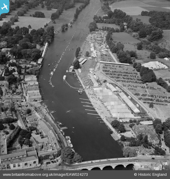
EAW024273 ENGLAND (1949). Remenham, The Royal Regatta, 1949
© Copyright OpenStreetMap contributors and licensed by the OpenStreetMap Foundation. 2026. Cartography is licensed as CC BY-SA.
Nearby Images (36)
Details
| Title | [EAW024273] Remenham, The Royal Regatta, 1949 |
| Reference | EAW024273 |
| Date | 29-June-1949 |
| Link | |
| Place name | REMENHAM |
| Parish | REMENHAM |
| District | |
| Country | ENGLAND |
| Easting / Northing | 476408, 182828 |
| Longitude / Latitude | -0.8981679378761, 51.538696212008 |
| National Grid Reference | SU764828 |
Pins
Be the first to add a comment to this image!


![[EAW024273] Remenham, The Royal Regatta, 1949](http://britainfromabove.org.uk/sites/all/libraries/aerofilms-images/public/100x100/EAW/024/EAW024273.jpg)
![[EAW024274] Remenham, The Royal Regatta, 1949](http://britainfromabove.org.uk/sites/all/libraries/aerofilms-images/public/100x100/EAW/024/EAW024274.jpg)
![[EAW044517] Remenham, The Henley Royal Regatta, 1952](http://britainfromabove.org.uk/sites/all/libraries/aerofilms-images/public/100x100/EAW/044/EAW044517.jpg)
![[EAW044543] Henley-on-Thames, the Henley Royal Regatta in progress and the town, 1952](http://britainfromabove.org.uk/sites/all/libraries/aerofilms-images/public/100x100/EAW/044/EAW044543.jpg)
![[EAW044544] Henley-on-Thames, the Henley Royal Regatta in progress and the town, 1952](http://britainfromabove.org.uk/sites/all/libraries/aerofilms-images/public/100x100/EAW/044/EAW044544.jpg)
![[EAW044545] Henley-on-Thames, the Henley Royal Regatta in progress and the town, 1952](http://britainfromabove.org.uk/sites/all/libraries/aerofilms-images/public/100x100/EAW/044/EAW044545.jpg)
![[EAW024272] Remenham, The Royal Regatta, 1949](http://britainfromabove.org.uk/sites/all/libraries/aerofilms-images/public/100x100/EAW/024/EAW024272.jpg)
![[EPW008861] Henley-on-Thames, an Eights race at the finish at the Royal Regatta, 1923](http://britainfromabove.org.uk/sites/all/libraries/aerofilms-images/public/100x100/EPW/008/EPW008861.jpg)
![[EAW045426] The town and Remenham Wood, Henley-on-Thames, 1952](http://britainfromabove.org.uk/sites/all/libraries/aerofilms-images/public/100x100/EAW/045/EAW045426.jpg)
![[EAW044537] Remenham, the Henley Royal Regatta in progress opposite Phyllis Court, 1952](http://britainfromabove.org.uk/sites/all/libraries/aerofilms-images/public/100x100/EAW/044/EAW044537.jpg)
![[EPW008856] Henley-on-Thames, an Eights race approaches the finish at the Royal Regatta, 1923](http://britainfromabove.org.uk/sites/all/libraries/aerofilms-images/public/100x100/EPW/008/EPW008856.jpg)
![[EAW044541] Remenham, the Henley Royal Regatta course from Phyllis Court to Temple Island, 1952](http://britainfromabove.org.uk/sites/all/libraries/aerofilms-images/public/100x100/EAW/044/EAW044541.jpg)
![[EAW044549] Remenham, the Henley Royal Regatta in progress, 1952](http://britainfromabove.org.uk/sites/all/libraries/aerofilms-images/public/100x100/EAW/044/EAW044549.jpg)
![[EPW035809] Henley-on-Thames, The Henley Royal Regatta at Henley Reach and Henley Bridge, 1931. This image has been produced from a copy-negative.](http://britainfromabove.org.uk/sites/all/libraries/aerofilms-images/public/100x100/EPW/035/EPW035809.jpg)
![[EPW008860] Henley-on-Thames, an Eights race approaches the finish at the Royal Regatta, 1923](http://britainfromabove.org.uk/sites/all/libraries/aerofilms-images/public/100x100/EPW/008/EPW008860.jpg)
![[EAW045423] Fawley Court and the town, Henley-on-Thames, 1952](http://britainfromabove.org.uk/sites/all/libraries/aerofilms-images/public/100x100/EAW/045/EAW045423.jpg)
![[EPW008853] Henley-on-Thames, the approach to the finish at the Royal Regatta, 1923](http://britainfromabove.org.uk/sites/all/libraries/aerofilms-images/public/100x100/EPW/008/EPW008853.jpg)
![[EPW008865] Henley-on-Thames, the approach to the finish at the Royal Regatta, 1923](http://britainfromabove.org.uk/sites/all/libraries/aerofilms-images/public/100x100/EPW/008/EPW008865.jpg)
![[EAW024271] Remenham, The Royal Regatta, 1949](http://britainfromabove.org.uk/sites/all/libraries/aerofilms-images/public/100x100/EAW/024/EAW024271.jpg)
![[EAW044540] Remenham, the Henley Royal Regatta course from Phyllis Court to Temple Island, 1952](http://britainfromabove.org.uk/sites/all/libraries/aerofilms-images/public/100x100/EAW/044/EAW044540.jpg)
![[EAW044516] Remenham, The Henley Royal Regatta, 1952](http://britainfromabove.org.uk/sites/all/libraries/aerofilms-images/public/100x100/EAW/044/EAW044516.jpg)
![[EPW008858] Henley-on-Thames, the approach to the finish at the Royal Regatta, 1923](http://britainfromabove.org.uk/sites/all/libraries/aerofilms-images/public/100x100/EPW/008/EPW008858.jpg)
![[EAW045422] The town centre, Henley-on-Thames, 1952](http://britainfromabove.org.uk/sites/all/libraries/aerofilms-images/public/100x100/EAW/045/EAW045422.jpg)
![[EAW045424] The town, Henley-on-Thames, 1952](http://britainfromabove.org.uk/sites/all/libraries/aerofilms-images/public/100x100/EAW/045/EAW045424.jpg)
![[EPW000855] Looking over Henley showing bridge, station and St Mary's Church, Henley-on-Thames, 1920](http://britainfromabove.org.uk/sites/all/libraries/aerofilms-images/public/100x100/EPW/000/EPW000855.jpg)
![[EPW008857] Henley-on-Thames, the approach to the finish at the Royal Regatta, 1923](http://britainfromabove.org.uk/sites/all/libraries/aerofilms-images/public/100x100/EPW/008/EPW008857.jpg)
![[EAW044538] Remenham, the Henley Royal Regatta course from Phyllis Court to Temple Island, 1952](http://britainfromabove.org.uk/sites/all/libraries/aerofilms-images/public/100x100/EAW/044/EAW044538.jpg)
![[EAW044551] Remenham, the Henley Royal Regatta in progress, 1952](http://britainfromabove.org.uk/sites/all/libraries/aerofilms-images/public/100x100/EAW/044/EAW044551.jpg)
![[EAW044547] Remenham, the Henley Royal Regatta in progress and the town, 1952](http://britainfromabove.org.uk/sites/all/libraries/aerofilms-images/public/100x100/EAW/044/EAW044547.jpg)
![[EAW044546] Remenham, the Henley Royal Regatta in progress and the town, 1952](http://britainfromabove.org.uk/sites/all/libraries/aerofilms-images/public/100x100/EAW/044/EAW044546.jpg)
![[EPW022749] St Mary's Church, Henley-on-Thames, 1928](http://britainfromabove.org.uk/sites/all/libraries/aerofilms-images/public/100x100/EPW/022/EPW022749.jpg)
![[EAW044553] Remenham, the Henley Royal Regatta in progress, 1952](http://britainfromabove.org.uk/sites/all/libraries/aerofilms-images/public/100x100/EAW/044/EAW044553.jpg)
![[EAW044552] Remenham, the Henley Royal Regatta in progress, 1952](http://britainfromabove.org.uk/sites/all/libraries/aerofilms-images/public/100x100/EAW/044/EAW044552.jpg)
![[EAW044518] Henley-on-Thames, The Henley Royal Regatta, 1952](http://britainfromabove.org.uk/sites/all/libraries/aerofilms-images/public/100x100/EAW/044/EAW044518.jpg)
![[EAW044536] Henley-on-Thames, the Henley Royal Regatta in progress opposite Phyllis Court, 1952](http://britainfromabove.org.uk/sites/all/libraries/aerofilms-images/public/100x100/EAW/044/EAW044536.jpg)
![[EAW044542] Remenham, the Henley Royal Regatta in progress, 1952](http://britainfromabove.org.uk/sites/all/libraries/aerofilms-images/public/100x100/EAW/044/EAW044542.jpg)