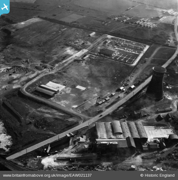
EAW021137 ENGLAND (1949). Part of the John Lysaght Ltd Normanby Park Steel Works, Scunthorpe, 1949. This image has been produced from a print.
© Copyright OpenStreetMap contributors and licensed by the OpenStreetMap Foundation. 2026. Cartography is licensed as CC BY-SA.
Nearby Images (48)
Details
| Title | [EAW021137] Part of the John Lysaght Ltd Normanby Park Steel Works, Scunthorpe, 1949. This image has been produced from a print. |
| Reference | EAW021137 |
| Date | 25-February-1949 |
| Link | |
| Place name | SCUNTHORPE |
| Parish | |
| District | |
| Country | ENGLAND |
| Easting / Northing | 488944, 414248 |
| Longitude / Latitude | -0.65524899701119, 53.616978152902 |
| National Grid Reference | SE889142 |
Pins
Be the first to add a comment to this image!


![[EAW021137] Part of the John Lysaght Ltd Normanby Park Steel Works, Scunthorpe, 1949. This image has been produced from a print.](http://britainfromabove.org.uk/sites/all/libraries/aerofilms-images/public/100x100/EAW/021/EAW021137.jpg)
![[EAW013488] The northern end of the John Lysaght Normanby Park Steel Works site, Scunthorpe, 1948. This image was marked by Aerofilms Ltd for photo editing.](http://britainfromabove.org.uk/sites/all/libraries/aerofilms-images/public/100x100/EAW/013/EAW013488.jpg)
![[EAW021136] Part of the John Lysaght Ltd Normanby Park Steel Works, Scunthorpe, 1949. This image has been produced from a print.](http://britainfromabove.org.uk/sites/all/libraries/aerofilms-images/public/100x100/EAW/021/EAW021136.jpg)
![[EAW023926] The John Lysaght Normanby Park Steel Works, Scunthorpe, 1949](http://britainfromabove.org.uk/sites/all/libraries/aerofilms-images/public/100x100/EAW/023/EAW023926.jpg)
![[EAW031183] The John Lysaght Normanby Park Steel Works, Scunthorpe, 1950](http://britainfromabove.org.uk/sites/all/libraries/aerofilms-images/public/100x100/EAW/031/EAW031183.jpg)
![[EAW027184] Part of the John Lysaght Normanby Park Steel Works, Scunthorpe, 1949](http://britainfromabove.org.uk/sites/all/libraries/aerofilms-images/public/100x100/EAW/027/EAW027184.jpg)
![[EAW034828] Part of the John Lysaght Normanby Park Steel Works, Scunthorpe, 1951. This image has been produced from a print.](http://britainfromabove.org.uk/sites/all/libraries/aerofilms-images/public/100x100/EAW/034/EAW034828.jpg)
![[EAW021138] Part of the John Lysaght Ltd Normanby Park Steel Works, Scunthorpe, 1949. This image has been produced from a print.](http://britainfromabove.org.uk/sites/all/libraries/aerofilms-images/public/100x100/EAW/021/EAW021138.jpg)
![[EAW034821] Part of the John Lysaght Normanby Park Steel Works, Scunthorpe, 1951. This image has been produced from a print.](http://britainfromabove.org.uk/sites/all/libraries/aerofilms-images/public/100x100/EAW/034/EAW034821.jpg)
![[EAW027183] Part of the John Lysaght Normanby Park Steel Works, Scunthorpe, 1949](http://britainfromabove.org.uk/sites/all/libraries/aerofilms-images/public/100x100/EAW/027/EAW027183.jpg)
![[EAW028570] Part of the John Lysaght Normanby Park Steel Works, Scunthorpe, 1950](http://britainfromabove.org.uk/sites/all/libraries/aerofilms-images/public/100x100/EAW/028/EAW028570.jpg)
![[EAW021139] John Lysaght Ltd Normanby Park Steel Works and adjacent Ironstone Quarry, Scunthorpe, 1949. This image has been produced from a print.](http://britainfromabove.org.uk/sites/all/libraries/aerofilms-images/public/100x100/EAW/021/EAW021139.jpg)
![[EAW021132] Part of the John Lysaght Ltd Normanby Park Steel Works, Scunthorpe, 1949. This image has been produced from a print.](http://britainfromabove.org.uk/sites/all/libraries/aerofilms-images/public/100x100/EAW/021/EAW021132.jpg)
![[EPW048946] The John Lysaght Normanby Park Steel Works, Scunthorpe, from the north-east, 1935](http://britainfromabove.org.uk/sites/all/libraries/aerofilms-images/public/100x100/EPW/048/EPW048946.jpg)
![[EAW019673] Part of the John Lysaght Normanby Park Steel Works under construction, Scunthorpe, 1948. This image has been produced from a print.](http://britainfromabove.org.uk/sites/all/libraries/aerofilms-images/public/100x100/EAW/019/EAW019673.jpg)
![[EAW028571] Part of the John Lysaght Normanby Park Steel Works, Scunthorpe, 1950](http://britainfromabove.org.uk/sites/all/libraries/aerofilms-images/public/100x100/EAW/028/EAW028571.jpg)
![[EAW013834] The John Lysaght Ltd Normanby Park Steel Works, Scunthorpe, 1948](http://britainfromabove.org.uk/sites/all/libraries/aerofilms-images/public/100x100/EAW/013/EAW013834.jpg)
![[EAW031182] The John Lysaght Normanby Park Steel Works, Scunthorpe, 1950](http://britainfromabove.org.uk/sites/all/libraries/aerofilms-images/public/100x100/EAW/031/EAW031182.jpg)
![[EAW034822] Part of the John Lysaght Normanby Park Steel Works, Scunthorpe, 1951. This image has been produced from a print.](http://britainfromabove.org.uk/sites/all/libraries/aerofilms-images/public/100x100/EAW/034/EAW034822.jpg)
![[EAW027182] Part of the John Lysaght Normanby Park Steel Works, Scunthorpe, 1949. This image was marked by Aerofilms Ltd for photo editing.](http://britainfromabove.org.uk/sites/all/libraries/aerofilms-images/public/100x100/EAW/027/EAW027182.jpg)
![[EAW028578] Part of the John Lysaght Normanby Park Steel Works, Scunthorpe, 1950. This image was marked by Aerofilms Ltd for photo editing.](http://britainfromabove.org.uk/sites/all/libraries/aerofilms-images/public/100x100/EAW/028/EAW028578.jpg)
![[EAW027178] The John Lysaght Normanby Park Steel Works, Scunthorpe, 1949](http://britainfromabove.org.uk/sites/all/libraries/aerofilms-images/public/100x100/EAW/027/EAW027178.jpg)
![[EAW013487] The northern end of the John Lysaght Normanby Park Steel Works site, Scunthorpe, from the south, 1948. This image was marked by Aerofilms Ltd for photo editing.](http://britainfromabove.org.uk/sites/all/libraries/aerofilms-images/public/100x100/EAW/013/EAW013487.jpg)
![[EAW013831] The John Lysaght Ltd Normanby Park Steel Works, Scunthorpe, 1948. This image was marked by Aerofilms Ltd for photo editing.](http://britainfromabove.org.uk/sites/all/libraries/aerofilms-images/public/100x100/EAW/013/EAW013831.jpg)
![[EAW019669] The John Lysaght Normanby Park Steel Works Opencast Ironstone Quarry, Scunthorpe, from the west, 1948. This image has been produced from a print.](http://britainfromabove.org.uk/sites/all/libraries/aerofilms-images/public/100x100/EAW/019/EAW019669.jpg)
![[EAW023925] The John Lysaght Normanby Park Steel Works, Scunthorpe, 1949](http://britainfromabove.org.uk/sites/all/libraries/aerofilms-images/public/100x100/EAW/023/EAW023925.jpg)
![[EAW041828] The John Lysaght Normanby Park Steel Works, Scunthorpe, 1952. This image has been produced from a print.](http://britainfromabove.org.uk/sites/all/libraries/aerofilms-images/public/100x100/EAW/041/EAW041828.jpg)
![[EAW013833] The John Lysaght Ltd Normanby Park Steel Works, Scunthorpe, 1948](http://britainfromabove.org.uk/sites/all/libraries/aerofilms-images/public/100x100/EAW/013/EAW013833.jpg)
![[EAW013832] The John Lysaght Ltd Normanby Park Steel Works, Scunthorpe, 1948](http://britainfromabove.org.uk/sites/all/libraries/aerofilms-images/public/100x100/EAW/013/EAW013832.jpg)
![[EPW048529] The John Lysaght Normanby Park Steel Works, Scunthorpe, from the north, 1935](http://britainfromabove.org.uk/sites/all/libraries/aerofilms-images/public/100x100/EPW/048/EPW048529.jpg)
![[EAW013490] The northern end of the John Lysaght Normanby Park Steel Works site, Scunthorpe, from the south-east, 1948. This image was marked by Aerofilms Ltd for photo editing.](http://britainfromabove.org.uk/sites/all/libraries/aerofilms-images/public/100x100/EAW/013/EAW013490.jpg)
![[EAW034818] A cooling tower at the John Lysaght Normanby Park Steel Works under construction, Scunthorpe, 1951. This image has been produced from a print.](http://britainfromabove.org.uk/sites/all/libraries/aerofilms-images/public/100x100/EAW/034/EAW034818.jpg)
![[EAW031173] The John Lysaght Normanby Park Steel Works, Scunthorpe, 1950. This image was marked by Aerofilms Ltd for photo editing.](http://britainfromabove.org.uk/sites/all/libraries/aerofilms-images/public/100x100/EAW/031/EAW031173.jpg)
![[EAW016662] John Lysaght Ltd Normanby Park Steel Works and environs, Scunthorpe, 1948](http://britainfromabove.org.uk/sites/all/libraries/aerofilms-images/public/100x100/EAW/016/EAW016662.jpg)
![[EPW048530] The John Lysaght Normanby Park Steel Works, Scunthorpe, from the north, 1935](http://britainfromabove.org.uk/sites/all/libraries/aerofilms-images/public/100x100/EPW/048/EPW048530.jpg)
![[EAW028583] Part of the John Lysaght Normanby Park Steel Works, Scunthorpe, 1950](http://britainfromabove.org.uk/sites/all/libraries/aerofilms-images/public/100x100/EAW/028/EAW028583.jpg)
![[EAW034829] Steam billowing from a shadowy Normanby Park Steel Works, Scunthorpe, from the north-east, 1951](http://britainfromabove.org.uk/sites/all/libraries/aerofilms-images/public/100x100/EAW/034/EAW034829.jpg)
![[EAW009411] The John Lysaght Normanby Park Steel Works, Flixborough, from the south-east, 1947. This image has been produced from a print.](http://britainfromabove.org.uk/sites/all/libraries/aerofilms-images/public/100x100/EAW/009/EAW009411.jpg)
![[EAW013489] The northern end of the John Lysaght Normanby Park Steel Works site, Scunthorpe, from the south-west, 1948. This image was marked by Aerofilms Ltd for photo editing.](http://britainfromabove.org.uk/sites/all/libraries/aerofilms-images/public/100x100/EAW/013/EAW013489.jpg)
![[EAW034811] Part of the John Lysaght Normanby Park Steel Works, Scunthorpe, 1951. This image has been produced from a print.](http://britainfromabove.org.uk/sites/all/libraries/aerofilms-images/public/100x100/EAW/034/EAW034811.jpg)
![[EAW038776] Part of the John Lysaght Ltd Normanby Park Steel Works, Scunthorpe, 1951. This image has been produced from a print.](http://britainfromabove.org.uk/sites/all/libraries/aerofilms-images/public/100x100/EAW/038/EAW038776.jpg)
![[EAW028575] Part of the John Lysaght Normanby Park Steel Works, Scunthorpe, 1950](http://britainfromabove.org.uk/sites/all/libraries/aerofilms-images/public/100x100/EAW/028/EAW028575.jpg)
![[EAW034805] Part of the John Lysaght Normanby Park Steel Works, Scunthorpe, 1951. This image has been produced from a print.](http://britainfromabove.org.uk/sites/all/libraries/aerofilms-images/public/100x100/EAW/034/EAW034805.jpg)
![[EPW048528] The John Lysaght Normanby Park Steel Works, Scunthorpe, 1935](http://britainfromabove.org.uk/sites/all/libraries/aerofilms-images/public/100x100/EPW/048/EPW048528.jpg)
![[EAW041863] Part of the John Lysaght Normanby Park Steel Works, Scunthorpe, 1952. This image was marked by Aerofilms Ltd for photo editing.](http://britainfromabove.org.uk/sites/all/libraries/aerofilms-images/public/100x100/EAW/041/EAW041863.jpg)
![[EAW031193] The John Lysaght Normanby Park Steel Works, Scunthorpe, 1950](http://britainfromabove.org.uk/sites/all/libraries/aerofilms-images/public/100x100/EAW/031/EAW031193.jpg)
![[EAW038778] Part of the John Lysaght Ltd Normanby Park Steel Works, Scunthorpe, 1951. This image has been produced from a print.](http://britainfromabove.org.uk/sites/all/libraries/aerofilms-images/public/100x100/EAW/038/EAW038778.jpg)
![[EAW034824] Part of the John Lysaght Normanby Park Steel Works, Scunthorpe, 1951. This image has been produced from a print.](http://britainfromabove.org.uk/sites/all/libraries/aerofilms-images/public/100x100/EAW/034/EAW034824.jpg)