
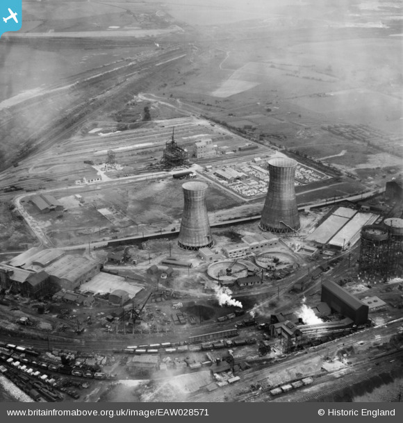
EAW028571 ENGLAND (1950). Part of the John Lysaght Normanby Park Steel Works, Scunthorpe, 1950
© Copyright OpenStreetMap contributors and licensed by the OpenStreetMap Foundation. 2026. Cartography is licensed as CC BY-SA.
Nearby Images (48)
EAW028571

EAW028570

EAW013834

EAW013831

EAW013832

EAW013833

EAW013490

EAW041828

EAW031173

EAW016662

EAW028583

EAW013489

EAW009411

EAW034811

EAW038776

EAW034829

EAW034805

EPW048528

EAW031193

EAW028575

EPW048530

EAW016661

EAW031196

EAW038778

EAW016658

EAW034824

EPW048523

EAW041846

EAW041851

EAW027181

EAW028563

EAW031188

EAW028560

EAW041847

EPW048529

EAW009637

EAW041848

EAW041854

EAW028564

EAW027179

EAW031187

EAW031195

EAW034804

EAW038775

EAW041852

EAW041858

EAW041857

EAW041853

Details
| Title | [EAW028571] Part of the John Lysaght Normanby Park Steel Works, Scunthorpe, 1950 |
| Reference | EAW028571 |
| Date | 5-April-1950 |
| Link | |
| Place name | SCUNTHORPE |
| Parish | |
| District | |
| Country | ENGLAND |
| Easting / Northing | 488853, 414192 |
| Longitude / Latitude | -0.65664039642891, 53.616490338847 |
| National Grid Reference | SE889142 |
Pins
Be the first to add a comment to this image!